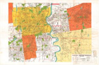
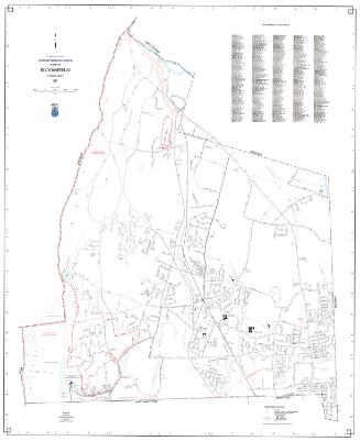
Map of Central Part of Hartford County, Conn.
PublisherPublished by
F. J. Miller
American, 1887 - 1972
RetailerSold by
Gustave Fischer Co.
American
RetailerSold by
Plimpton's
American, founded 1865
Date1954-1956
MediumLithography; black, red, and blue printer's ink on wove paper
DimensionsPrimary Dimensions (image height x width): 57 x 41 3/4in. (144.8 x 106cm)
Sheet (height x width): 59 1/2 x 42 1/4in. (151.1 x 107.3cm)
Sheet (height x width): 59 1/2 x 42 1/4in. (151.1 x 107.3cm)
ClassificationsGraphics
Credit LineMuseum purchase
DescriptionMap of a large portion of Hartford County, including Hartford, East Hartford, Manchester, South Windsor, Glastonbury, Rocky Hill, Wethersfield, New Britain, Berlin, West Hartford, Bloomfield, Windsor, and parts of Farmington, Avon, Simsbury, Granby, East Granby, Windsor Locks, and East Windsor. Rivers and ponds are colored blue. All state highways, local roads, and streets are identified by name or number. A "proposed expressway" is shown crossing the Connecticut River at Windsor Locks. A key to the streets extends across the lower portion of the map and continues at upper right..
Object number1956.95.6
MarkingsOn verso, lower left, on gummed label, typed in black ink, "MAPS / Case 3 / No. 11"On verso, lower right, on gummed label, typed in black ink, "MAPS / Case 3 / No. 11"InscribedOn recto, upper right, printed in black ink, "Map of / CENTRAL PART OF / HARTFORD COUNTY / CONN. / PUBLISHED BY F. J. MILLER / 1045 High St., Westwood, Mass. / COPIES OF THIS MAP / CAN BE PURCHASED FROM / PLIMPTON'S / HARTFORD WEST HARTFORD / NEW BRITAIN / THE GUSTAVE FISHER [sic] CO. / ASYLUM ST. HARTFORD / COPYRIGHTED BY F. J. MILLER / ALL RIGHTS RESERVED"
On verso, lower right, in pencil, "MAPS / Case 3 / No. 11" / "1956.95.6"
On verso, lower left, in pencil, "MAPS / Case 3 / No. 11"NotesCartographic Note: 2 3/8 inches equals one mile
Subject Terms
- Hartford County (Conn.)
- Hartford (Conn.)
- East Hartford (Conn.)
- South Windsor (Conn.)
- Manchester (Conn.)
- Glastonbury (Conn.)
- Rocky Hill (Conn.)
- Wethersfield (Conn.)
- New Britain (Conn.)
- Berlin (Conn.)
- West Hartford (Conn.)
- Bloomfield (Conn.)
- Windsor (Conn.)
- Connecticut River
- Lithographs
- County Maps
- Map Cataloging Project
Collections
- Maps and Charts: Finding Your Place in Connecticut History
On View
Not on view