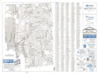
Map Showing Location of Reservoirs and Extent of Watershed for the Hartford Water Works
SurveyorSurveyed by
Seth E. Marsh
American, about 1823 - 1878
SurveyorSurveyed by
Henry W. Ayres
American, 1848 - 1912
MakerMade for the
Hartford Water Company
American, founded 1851
Date1875
MediumDrawing; black ink, blue watercolor, and blue crayon on wove paper on fabric
DimensionsPrimary Dimensions (image height x width): 40 3/4 x 76 3/4in. (103.5 x 194.9cm)
Sheet (height x width): 43 1/2 x 80in. (110.5 x 203.2cm)
Sheet (height x width): 43 1/2 x 80in. (110.5 x 203.2cm)
ClassificationsGraphics
Credit LineConnecticut Museum of Culture and History collection
DescriptionMap of parts of Farmington, West Hartford, and Avon, showing the locations of Reservoirs No. 1, 2, 3, and 5. Dyke Pond, Trout Brook, Mine Brook, Long's Pond, and other streams and ponds are shown. Existing and proposed canals connecting the reservoirs are shown. Roads include the Albany Turnpike (present day Route 44) with toll house, Mountain Spring Road, Farmington Road (Farmington Avenue), Middle Road, and South Road. Names of property owners are given. Elevation is indicated with hachure marks. A four-point compass rose is at upper right.
Object number1970.27.23
MarkingsOn verso, lower left, stamped in blue ink, "CtHi"; stamped in black ink, "4---1"Lower right, stamped in black ink, "4---1"
Upper right, stamped in black ink, "4---1"InscribedOn recto, lower right, in black ink, "Map / SHOWING LOCATION OF / RESERVOIRS / AND / EXTENT OF WATERSHED / FOR THE / Hartford Water Works. / From Surveys in the Winter of 1875. / SETH E. MARSH C.E. H.W. AYRES C.E. ASS'T. / Scale 400 feet to an Inch"
On verso, lower left, in black ink, "acc 088135" "1970-27-23"
Upper left, in black ink, "acc 088135: "1970-27-23"; in pencil, "North Map - Water Shed &c."
Lower right, in pencil, "North Map - Water Shed &c"NotesCartographic Note: One inche equals 400 feet
Collections
- Maps and Charts: Finding Your Place in Connecticut History
On View
Not on view