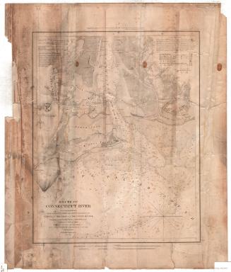
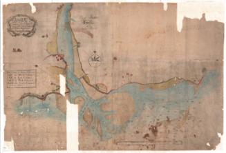
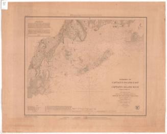
Mouth of Connecticut River
PublisherPublished by the
United States Coast Survey
American, founded 1807
MakerTopography by
Henry L. Whiting
American, 1821 - 1897
SurveyorTriangulation by
William Harrison Swift
American
SurveyorTriangulation by
Edmund March Blunt
1770 - 1862
MakerHydropgraphy under the direction of
John R. Goldsborough
American, 1809 - 1877
MakerHydrography under the direction of
Maxwell Woodhull
American, 1813 - 1863
MakerMagnetic observations by
James Renwick
American, 1792 - 1863
PrintmakerElectrotyped by
George Mathiot
American, died 1873
SurveyorUnder the direction of
Alexander Dallas Bache
American, 1806 - 1867
SurveyorUnder the direction of
Ferdinand Rudolph Hassler
American, 1770 - 1843
Date1853
MediumElectrotype; black printer's ink and watercolor on wove paper
DimensionsPrimary Dimensions (image height x width): 17 3/8 x 14in. (44.1 x 35.6cm)
Platemark (width only): 17 3/4in. (45.1cm)
Sheet (height x width): 21 3/4 x 18 3/8in. (55.2 x 46.7cm)
Platemark (width only): 17 3/4in. (45.1cm)
Sheet (height x width): 21 3/4 x 18 3/8in. (55.2 x 46.7cm)
ClassificationsGraphics
Credit LineMuseum purchase
DescriptionChart of the mouth of the Connecticut River where it meets the Long Island Sound, with Lyme Creek to the north, Griswold's Cove to the east, the Long Island Sound to the south, and South and North Coves to the west. Water depth is marked first in feet to 18 feet and then in fathoms, and is also hand-colored in shades of blue to reflect depth. The surrounding land is also shown, with lines and symbols used to indicate different types of land. These are also hand-colored in shades of green and yellow. Along the roads, clusters of black squares indicate the presence of buildings, and these areas are colored red. To the top left of the chart is information about the latitude and longitude, the courses, bearings, and soundings. To the top right are sailing directions and tide information.
Object number1981.146.0
MarkingsVerso, right side, stamped in blue ink: "CtHi"Right side, stamped in blue ink: "THE CONNECTICUT / 81528 / HISTORICAL SOCIETY"InscribedRecto, top, printed in black ink: "Presented under Authority of an Act of Congress of the United States of June 3d. 1844 & by direction of the Treasury Department / A.D. Bache Superintendent Coast Survey"
Top right, printed in black ink: "Electrotype Copy No. 1 by G. Mathiot U.S.C.S."
Top left, printed in black ink: "The Magnetic observations in 1843 by Prof. J. Renwick"
Left side, printed in black ink: "U.S. COAST SURVEY OFFICE"
Left side, printed in black ink: "Verified / H.W. Benham, Capt. of Engrs. / Asst. in charge of Office"
Bottom left, printed in black ink: "MOUTH OF / CONNECTICUT RIVER / From a Trigonometrical Survey / under the direction of F.R. HASSLER and A.D. BACHE Superintendents of the / SURVEY OF THE COAST OF THE UNITED STATES / Triangulation by CAPT. W.H. SWIFT U.S.A. and E. BLUNT Assistants / Topography by H.L. WHITING Assistant / Hydrography by the parties under the command of / Lieuts. J.R. GOLDSBOROUGH and M. WOODHULL U.S.N. Assts. / Published in 1853 / A.D. BACHE Superintendent / Scale 1/20 000"
Bottom left, printed in black ink: "Redd. Drng. by A. Boschke."
Bottom right, printed in black ink: "Engd. by S. Siebert, O.A. Lawson & W. Smith"
Verso, top left, handwritten in pencil: "Map / Box / 69a"
Top left, handwritten in pencil: "75"
Bottom left, handwritten in pencil: "MAP Box / 69a"NotesCartographic Note: Scale: 1:20,000
Collections
- Maps and Charts: Finding Your Place in Connecticut History
On View
Not on view

Object/Object