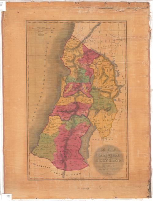
Map of Palestine or the Holy Land
PublisherPublished by
D. F. Robinson & Co.
American, 1828 - 1834
Date1831
MediumEngraving; black printer's ink and watercolor on wove paper, lined with linen
DimensionsPrimary Dimensions (image height x width): 20 x 12 3/4in. (50.8 x 32.4cm)
Sheet (height x width): 24 1/2 x 18 1/4in. (62.2 x 46.4cm)
Mount (height x width): 24 1/2 x 18 1/2in. (62.2 x 47cm)
Sheet (height x width): 24 1/2 x 18 1/4in. (62.2 x 46.4cm)
Mount (height x width): 24 1/2 x 18 1/2in. (62.2 x 47cm)
ClassificationsGraphics
Credit LineMuseum purchase
DescriptionMap of the region of Palestine, with Syria to the north, "Arabia" (present-day Jordan) to the east, ancient Edom (part of present-day Israel) to the south, and the Mediterranean Sea to the west. The area is divided into regions that correspond with ancient kingdoms and geographic zones, and are labeled. Physical features depicted include elevation, conveyed with hachure marks; seas; and rivers. Royal cities, cities of refuge, and Levitical cities are marked with symbols listed in the Explanation.
Object number1963.98.0
MarkingsRecto, top and bottom left corners, printed in black ink on stickers: "MAPS / Box / 291"InscribedRecto, bottom right, printed in black ink: "MAP / OF / PALESTINE / OR THE / HOLY LAND. / Hartford: / PUBLISHED BY D.F. ROBINSON & Co. / 1831."NotesCartographic Note: about 1/2 inch equals 5 milesCollections
- Maps and Charts: Finding Your Place in Connecticut History
On View
Not on view