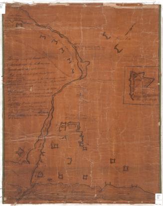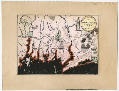
Harvard College Farms in the Pequot Country as laid out in 1658
DraftsmanDrawn by
Erwin Raisz
Hungarian-American, 1893 - 1968
Dateafter 1931
MediumPhotostat; black ink, marker and crayon on wove paper
DimensionsPrimary Dimensions (image height x width): 8 x 10 3/4in. (20.3 x 27.3cm)
Sheet (height x width): 12 x 15 1/4in. (30.5 x 38.7cm)
Sheet (height x width): 12 x 15 1/4in. (30.5 x 38.7cm)
ClassificationsGraphics
Credit LineGift of C.E.H. Whitlock
DescriptionCopy of a map depicting the location of Harvard College's farms in New London County, Connecticut, and Washington County, Rhode Island. There are four numbered farms and two unnumbered ones, all of them depicted in green and labeled with the number of acres they contain. The map also shows the location of a Stonington-area meeting house in 1667, a fort fight in 1637, George Denison's house, and the Cheseborough house. Physical features depicted include elevation, conveyed through hachure marks; the Shonock River, Lambs Brook and other waterways; and what appears to be marshland.
Object number1969.68.0
MarkingsRecto, bottom right, typed in black ink on paper: "NEW LONDON CO. CT. WHITLOCK'S. NEW HAVEN, CT."Verso, center, stamped in blue ink: "CtHi"InscribedRecto, top right, printed in black ink: "Harvard College Farms / in the / PEQUOT COUNTRY / as laid out in / 1658 / Drawn by Erwin Raisz Ph.D."
Bottom right, printed in black ink: "RAISZ"
Verso, top left, handwritten in pencil: "72752"NotesCartographic Note: Scale: about 13/16 inch equals 1 mile
Constituent Note: The New Haven bookseller C. E. H. Whitlock gave the map to the Connecticut Historical Society in 1969, but there seems to be no reason to think that he played any role in its production.
Collections
- Maps and Charts: Finding Your Place in Connecticut History
On View
Not on view