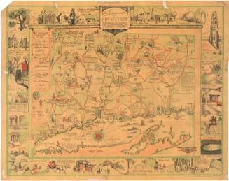
Map of the City of Hartford, Connecticut
After a work byAfter a work by
Daniel Saint John
American, 1761 - 1846
After a work byAfter a work by
Nathaniel Goodwin
American, 1782 - 1855
PrinterPrinted by
Aetna Life Insurance Co.
American
Date1935
MediumLithography; black printer's ink on wove paper
DimensionsPrimary Dimensions (image height x width): 12 3/4 x 10 1/4in. (32.4 x 26cm)
Sheet (height x width): 16 3/8 x 10 3/4in. (41.6 x 27.3cm)
Sheet (height x width): 16 3/8 x 10 3/4in. (41.6 x 27.3cm)
ClassificationsGraphics
Credit LineConnecticut Museum of Culture and History collection
DescriptionMap of Hartford, Connecticut, showing the city as it appeared in the early nineteenth century. The streets are labeled and there are six circled numbers on the map that show the locations of buildings or sites important to Hartford's or Aetna Insurance Company's history: the State House, Morgan's Exchange Coffee House, Phoenix Bank, the Charter Oak, Washington College (now Trinity College), and the old burying ground. Text below the map explains Aetna's history and some of Hartford's.
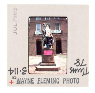
On the back are ten images depicting scenes celebrating Connecticut during its tercentenary year. Clockwise from center, they are: a mural in the State Library showing the creation of the "Fundamental Orders;" a statue of Thomas Hooker; Connecticut Hall at Yale University; the school at which Nathan Hale taught in 1774-5; what was probably the largest and oldest elm in the country, in Wethersfield; a pageant scene depicting Thomas Hooker and his followers arriving in Hartford in 1636; the oldest stone house in the state, in Guilford; the Old State House in Hartford; the Webb House in Wethersfield; and a statue of Nathan Hale.
On the back are ten images depicting scenes celebrating Connecticut during its tercentenary year. Clockwise from center, they are: a mural in the State Library showing the creation of the "Fundamental Orders;" a statue of Thomas Hooker; Connecticut Hall at Yale University; the school at which Nathan Hale taught in 1774-5; what was probably the largest and oldest elm in the country, in Wethersfield; a pageant scene depicting Thomas Hooker and his followers arriving in Hartford in 1636; the oldest stone house in the state, in Guilford; the Old State House in Hartford; the Webb House in Wethersfield; and a statue of Nathan Hale.
Object number2006.135.0
InscribedRecto, top left, printed in black ink: "MAP OF THE CITY OF HARTFORD, CT. / Redrawn from an old / map published in 1824 / from survey made / by D. St. John and / N. Goodwin"Bottom right, printed in black ink: "Printed at Hartford for distribution during Connecticut's Tercentenary Year / by AETNA INSURANCE COMPANY, HARTFORD, CONNECTICUT / 1819 .... One Hundred and Sixteen Years of Fire Insurance .... 1935"
Bottom left, handwritten in pencil: "[99414]"
Verso, right side, handwritten in pencil: "[99414"NotesCartographic Note: Scale: About 2 3/16 inches equals 1500 feet
Subject Terms
- Hartford (Conn.)
- Aetna Life Insurance Company (Hartford, Conn.)
- Connecticut River
- Park River (Hartford, Conn.)
- Rivers
- Old State House (Hartford, Conn.)
- Phoenix Bank (Hartford, Conn.)
- Charter Oak (Hartford, Conn.)
- Trinity College (Hartford, Conn.)
- Cemeteries
- Hale, Nathan, 1755-1776
- Webb house, Wethersfield, Conn.
- Guilford (Conn.)
- Connecticut State Library
- Yale University
- Elm
- Trees
- Wethersfield (Conn.)
- Lithographs
- Historical Maps
- City and Town Maps
- Map Cataloging Project
- Hartford
Collections
- Maps and Charts: Finding Your Place in Connecticut History
On View
Not on view