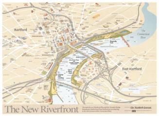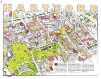
A View of Hartford
PublisherPublished by
The Hartford Courant
American, founded 1764
Date1989
MediumLithography; black and colored printer's inks on wove paper
DimensionsPrimary Dimensions (image height x width): 35 1/4 x 23 1/4in. (89.5 x 59.1cm)
Sheet (height x width): 36 x 24in. (91.4 x 61cm)
Sheet (height x width): 36 x 24in. (91.4 x 61cm)
ClassificationsGraphics
Credit LineGift of Ursula Korzenik
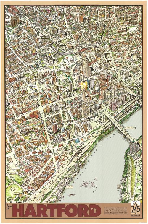
DescriptionBird's-eye view of part of Hartford, Connecticut commemorating the 225th anniversary of the Hartford Courant. Asylum Hill is to the north, Founders Bridge to the east, Colt Park to the south, and Frog Hollow to the west. The image shows the city streets, buildings (businesses, residences and public buildings), traffic in the city and on the freeways, and boats in the river. Some of the notable buildings are labeled (the Civic Center, the Old State House, City Hall, Wadsworth Atheneum, etc.), as are the neighborhoods. The poster was produced by the Hartford Courant, and a short paragraph at the bottom of the sheet describes the city's and the newspaper's growth.
Object number2004.142.6
MarkingsVerso, top left corner, stamped in black ink: "Connecticut Historical Society / Library"InscribedRecto, bottom left, printed in black ink: "© 1989 THE / HARTFORD / COURANT"Bottom left, printed in black ink: "A / VIEW / OF / HARTFORD"
Verso, top left corner, handwritten in pencil: "98456"NotesCartographic Note: No scale
Subject Terms
- Hartford (Conn.)
- Connecticut River
- Rivers
- Old State House (Hartford, Conn.)
- Hartford Civic Center (Hartford, Conn.)
- Wadsworth Atheneum (Hartford, Conn.)
- City halls
- Bushnell Park
- Capitols
- Hartford Courant
- Union Place (Hartford, Conn.)
- Corning Fountain (Hartford, Conn.)
- Connecticut State Library
- Lithographs
- Bird's-eye views
- City and Town Maps
- Map Cataloging Project
- Hartford
Collections
- Maps and Charts: Finding Your Place in Connecticut History
On View
Not on view