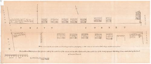
Map of Pratt Street, Hartford, Connecticut
MakerMade by
Nathaniel Goodwin
American, 1782 - 1855
Dateearly 20th century
MediumLithography; black printer's ink on wove paper
DimensionsPrimary Dimensions (image height x width): 11 1/2 x 27 1/4in. (29.2 x 69.2cm)
Sheet (height x width): 11 1/2 x 27 1/4in. (29.2 x 69.2cm)
Sheet (height x width): 11 1/2 x 27 1/4in. (29.2 x 69.2cm)
ClassificationsGraphics
Credit LineGift of Mrs. Mannis Oppenheimer
DescriptionPratt Street in Hartford, Connecticut, between Main and Trumbull Streets, oriented south-north on the sheet, with squares showing the locations of buildings along the street. The name of the owner or business is provided, along with the distance in feet from a specific point on the property (the water table, brick work, basement, etc.) to the northeast and northwest corner for those properties on the south side of the street and the southeast and southwest corner for those on the north side. At each of the corners are pairs of letters. A note below the map states that the lines of Pratt Street are building lines established by the Court of Common Council.
Object number1985.210.0
MarkingsRecto, top left corner, printed in black ink on sticker: "MAPS / Box / 179"Verso, bottom right corner, stamped in blue ink: "CtHi"InscribedRecto, bottom, printed in black ink: "The measures from the corners of the several buildings to the lines of the highways, are taken in the east and west lines of the buildings, extended to said street lines."
Bottom, printed in black ink: "The lines NO and PQ (the former 2 feet 9 inches south of the south line of the street, and the latter 6 feet north of the north line of the street,) representing Building Lines, established by the Court / of Common Council."
Bottom left, printed in black ink: "by N. GOODWIN, from a Survey made / October 23, 1835."
Verso, bottom right corner, handwritten in pencil: "85199"NotesCartographic Note: Scale: About 1 inch equals 25 feet
Collections
- Maps and Charts: Finding Your Place in Connecticut History
On View
Not on view