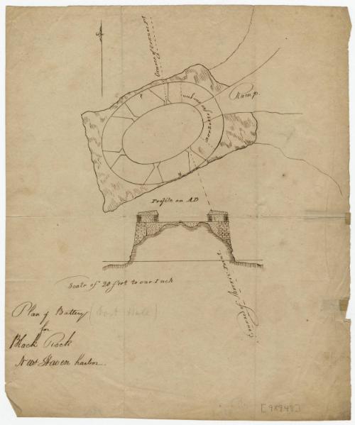
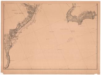
Plan of Battery for Black Rock, New Haven Harbor
DraftsmanDrawn by
Unknown
Dateabout 1776
MediumDrawing; black ink on paper
DimensionsPrimary Dimensions (image height x width): 9 5/8 x 8in. (24.4 x 20.3cm)
Sheet (height x width): 9 5/8 x 8in. (24.4 x 20.3cm)
Sheet (height x width): 9 5/8 x 8in. (24.4 x 20.3cm)
ClassificationsGraphics
Credit LineMuseum purchase
DescriptionPlan and elevation of the battery at Black Rock, on New Haven Harbor. The courses of Morris Point and Cranes Point are shown, and a barbette for one gun.
Object number2003.338.0
MarkingsRecto, top left corner, printed in black ink on sticker: "Maps / Box / 298"InscribedRecto, bottom left, handwritten in black ink: "Plan of Battery / for / Black Rock / New Haven harbor."Bottom left, handwritten in pencil: "(Fort Hale)"
Bottom right, handwritten in pencil: "[98948]"
Verso, bottom left, handwritten in pencil: "98306"
Bottom center, handwritten in pencil: "98306"NotesCartographic Note: Scale: 1 inch equals 20 feet
Collections
- Maps and Charts: Finding Your Place in Connecticut History
On View
Not on view


Lucius Stebbins & Co.
1859

R. A. Welcke Offset Co.
probably 1967