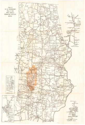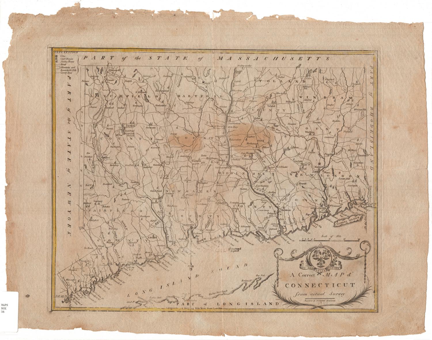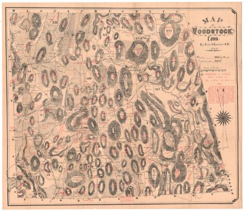
Map of Woodstock, Connecticut
SurveyorSurveyed by
John S. Lester
American, 1835 - 1910
MakerNames added by
George Clinton Williams
American, 1853 - 1931
PrinterPrinted by
Heliotype Printing Co.
American, 1872 - 1908
Date1883
MediumHeliotype; black and red printer's inks on wove paper, lined with linen
DimensionsPrimary Dimensions (image height x width): 24 x 27 7/8in. (61 x 70.8cm)
Sheet (height x width): 25 1/4 x 28 7/8in. (64.1 x 73.3cm)
Mount (height x width): 25 1/4 x 28 7/8in. (64.1 x 73.3cm)
Sheet (height x width): 25 1/4 x 28 7/8in. (64.1 x 73.3cm)
Mount (height x width): 25 1/4 x 28 7/8in. (64.1 x 73.3cm)
ClassificationsGraphics
Credit LineConnecticut Museum of Culture and History collection
DescriptionMap of Woodstock, Connecticut, from the border of Massachusetts to the north, Putnam and Thompson to the east, Eastford and Pomfret to the south, and Union and Eastford to the west. The map primarily shows the local hills, conveyed with hachure marks and labeled in red. Also in red are historical names and dates related to buildings and landowners. The town is divided into seventeen sections, divided by broken solid lines. Roads are denoted with solid parallel lines and some of them are labeled. Buildings, probably mostly houses, are indicated with solid black squares and the owner's name if known.
Object number2012.312.205
InscribedRecto, top right, printed in black ink: "MAP / OF / WOODSTOCK / Conn. / By John S. Lester C.E. / AREA 59 1/6 Sq MILES. / POPULATION 3610"Right side, printed in red ink: "TOPOGRAPHICAL & HISTORICAL / NAMES, ADDED BY / GEO. CLINTON WILLIAMS A.M. / 1886."
Right side, printed in red ink: "N.B. The authorities for the names / used are the Statutes, Town and other / Records, Usage, Historical and Natural / facts, and early occupation or ownership. / Formerly the terms "North, South, and West Parish," or "New Roxbury," "Old / Town," or "The Common," "Arnold Town," / "Muddy Brook," "Village Corners," "The / City," and "Stogy Hollow," were familiar / local names for the different communities. / The dotted parallel lines are old "range" / or "cross" roads. The names of house / owners are not all coontemporary."
Bottom right corner, printed in black ink: "HELIOTYPE PRINTING COMPANY, BOSTON."
Map Transcription
Names of property owners indicated on the map include:
Area I:
[near the Norwich and Springfield Turnpike]
M. Green (occurs twice), R.F. Towne, Mrs. W. Lyon, G. Sumner (occurs twice), George Spaulding, Miller, P. M. Law, C. T. Lyon (?), P. Kane, S. T. Morse, F. Flynn, B. S., Gaylord, S. H., A. C. Gordon, S. Phillips, Dr. G. A. Bowen, A. Chandler, E. Bowen, W. P. Snow, J. R. Davenport, J. F. Russell, F. Blackmer, John McClella, H. C. Bowen, Mrs. A. W. Bowen, Mrs. A. Carroll, C. R. Wilcox, G. Randall, Woodward, W. D. Carroll (?), J. J. W[illegible]amson, K. Tourtellotte (?), M. H. Williams, H. C. Bowen
[near the Westward Hill]
J. Mehan, W. W. Webber
[near the Roxbury Hill]
Z. Margy, Mehan
[near Fisher Hill]
M. E. Lyon
[near Rocky Hills]
J. O. Fox, E. Weaver, King
[near Cortney Hill]
A. Ber[illegible]ume
Area II:
[near the Norwich and Springfield Turnpike]
Moffitt, Brun, H. Snow, D. K. Thorne, Dr. Shaw, R. Wetherell (?), M. Paine, L. Putter, E. T. Warner, McCellan, A. Lake, N. T. Adams, G. S. F. Stoddard, A. Se[illegible]thworth, W. Arnold, C. Sheldon, W. B. Mathewson, General Sam McClellan
[near Mathewson Woods]
Dr. A. Mathewson, C. H. Porter, F. Rockwell
[near Sander Hill]
J. Low, O. Perry, E. I. Warner
[near Rocky Hill]
R. Hammond, B. Shields
Area III:
J. Jaunsen, J. Reuherd (?), E. Fennir, E. S. Bugbee, A. Child, H. Reynolds, D. C. Cumins, H. T. Child, S. H., E. Gorcoran (?), J. Randall, W. A. Moffitt, N. C. Bartlett, R. King, S. C. Houghton, L. Linderman, S. Palmer, H. Hubbard, D. Hubbard, G. Bugbee, F. Sampson, J. [illegible], J. Fuler, Mrs. Bishop, F. M. Fox, W. Catlin, Rev. Camp, Neidhart
Area IV:
J. Place, Otis Lyon, J. Green (Foxborough Hill),
[near Long Hill]
C. C. Williams, B. Williams, L. U. Wells (?), D. Baker
[near Wafpaquassef Hill]
Mrs. Swain, E. Hawkins (?), E. W. S[illegible]nger, B. Carroll, M. Fuller (?)
[near Masha Muggett]
F. Wilkinson, J. Thylon (?), Johnsen, Quarry, D. Young
Area V:
G. W. Weaton, J. F Pankhurst, Palmer, Johnson, Mrs. Johnson, A. Lippitt, G. M., L. Palmer, Otis Barrett, A. Chandler, M. Paine, A. Wetherell, Dr. Shaw, D. K. Thorne
Area VI:
D. Florich, Mrs. Phelps, L. Bacon (?), Johnson, S. H., L. Joslin, S. G. Hopkins, Phillips, Nichols, C. C. Foster,
[near Bundy Hill]
J. Petitt, M. L. Gage, D. Crewford
[near Joe Marcy Hill]
W. Myers, Carroll, Mrs. Wilkinson
[near Mason Hill]
W. Britton, Thomas Phillips, A. F. Clark, Mrs. Pike, B. Tucker
Area VII:
A. Marcy, J. E. Dean, Parker J. Church, I. Corbin, J. M. Per[illegible], M. B. McCom[illegible], W. Lyon, George Lyon, S. D. Skinner, Mrs. C. Allen, A. Bicknell, D. White, H. M., J. Chandler
[On the County Road]
Bradford, Bundy, Skinner, Phillips, Carpenter, Wilkinson, Litchfield, Scarborough, Williams, Marcy, Fox, Ellis, Hammond, Fisher
Area VIII:
[near the Hammond Hill] B. Carprey, N. Root, G. M., Sorghun, E. Simmons, S. H.
[near the Perrin Hill] N. Andrews, S. Bradford, H. K. Safford, O. D[illegible]
[near the Matthewson Hill] E. Arnold, Bradford, R. Hammond, A. B. Skinners
[near the Johnson Hill] G. Johnson, M. Smith
[near the Smith Hill] Mrs. Buck, J. Rafferty, D. Young
[near Skinner Hill] W. [illegible]amo[illegible]omd (?), Mrs. [illegible]len, C. Skinner
Mrs. Withy, Seth PierceNotesCartographic Note: 3 inches equals 1 mile
Collections
- Maps and Charts: Finding Your Place in Connecticut History
On View
Not on view