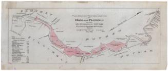
Plan Showing Location of Trees on Lands of Messrs J. J. and F. Goodwin
DraftsmanDrawn by
Unknown
Date1898
MediumDrawing; black ink, pencil, and watercolor on wove paper, lined with tissue
DimensionsPrimary Dimensions (image height x width): 25 x 28 1/2in. (63.5 x 72.4cm)
Sheet (height x width): 27 3/8 x 30 3/4in. (69.5 x 78.1cm)
Mount (height x width): 27 x 30 3/4in. (68.6 x 78.1cm)
Sheet (height x width): 27 3/8 x 30 3/4in. (69.5 x 78.1cm)
Mount (height x width): 27 x 30 3/4in. (68.6 x 78.1cm)
ClassificationsGraphics
Credit LineConnecticut Museum of Culture and History collection
DescriptionMap of the properties of J.J. and F. Goodwin in Hartford, Connecticut, at the intersection of Asylum Avenue and Woodland Street, with the Park River to the north. The buildings are outlined but not labeled, as the emphasis of the map is on the landscape, with little drawings of the trees and shrubs, labeled with their scientific names. Some of them are colored varying shades of green, but most of them are unfinished.
Object number2012.312.164
MarkingsRecto, top and bottom left corners, printed in black ink on stickers: "MAPS / Drawer / 16"InscribedRecto, bottom, hand-drawn in black ink: "PLAN SHOWING / LOCATION OF TREES / ON LANDS OF / MESSRS J.J. AND F. GOODWIN / Scale 40 ft. to an inch / JULY 1898"NotesCartographic Note: Scale: 1 inch equals 40 feetCollections
- Maps and Charts: Finding Your Place in Connecticut History
On View
Not on view
Anderson & Reeves
1888


William C. Stanton
1848