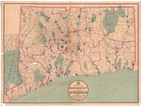
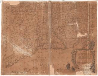
Map of the State of Connecticut to accompany the Fourth Report of the State Sewerage Commission
PrinterPrinted by
Kellogg & Bulkeley
American, 1867 - 1990
PublisherPublished by
Connecticut State Sewerage Commission
American, 1899 - 1903
Date1902
MediumLithography; black and colored printer's inks on paper
DimensionsPrimary Dimensions (image height x width): 24 1/4 x 32 7/8in. (61.6 x 83.5cm)
Sheet (height x width): 25 3/8 x 34in. (64.5 x 86.4cm)
Sheet (height x width): 25 3/8 x 34in. (64.5 x 86.4cm)
ClassificationsGraphics
Credit LineConnecticut Museum of Culture and History collection
DescriptionMap of Connecticut, from Massachusetts to the north, Rhode Island to the east, the Long Island Sound to the south, and New York to the west. It shows potable water supply areas, regions supplied with water, and areas supplied with water and having sewer systems, all color- and line-coded. Natural features include rivers, lakes and islands, and some railroad lines are depicted.
Object number2012.312.121
MarkingsRecto, bottom left and right corners, printed in black ink on sticker: "MAPS / Drawer / 92"InscribedRecto, center bottom, printed in black ink: "MAP OF THE / STATE OF CONNECTICUT / TO ACCOMPANY / THE FOURTH REPORT OF THE / STATE SEWERAGE COMMISSION / SHOWING / POTABLE WATER SUPPLIES, THUS [color and line coding] / AREAS SUPPLIED WITH WATER, THUS [color and line coding] / AREAS SUPPLIED WITH WATER AND / HAVING SEWER SYSTEMS, THUS [color and line coding] / SCALE / 1902"NotesCartographic Note: Scale: 1 7/8 inches equals 6 milesCollections
- Maps and Charts: Finding Your Place in Connecticut History
On View
Not on view
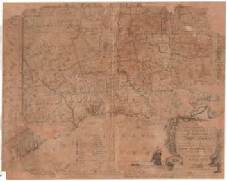
Joel Knott Allen
1792
Joel Knott Allen
1791 or 1792