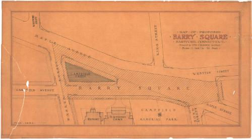
Map of Proposed Barry Square, Hartford, Connecticut
MakerPrepared by
John J. McMahon
American, 1875 - 1958
Date1934
MediumDrawing; black ink and red pencil on vellum
DimensionsSheet: 19 5/8 x 35 1/2in. (49.8 x 90.2cm)
ClassificationsGraphics
Credit LineGift of Paul R. McMahon, Jr.
DescriptionDrawing includes map of propsed Barry Square. Plan includes Webster Street, King Street, Maple Avenue, Bond Street, Campfield, Memorial, Rectory, Saint Augustine's Church, Campfield Green, Mountford Street and Barker Street.
Object number2009.8.5
InscribedOn recto, upper right, in balck ink and red pencil; "MAP OF PROPOSED / BARRY SQUARE / HARTFORD, CONNECTICUT". Numerous inscriptions identify parts of buildings, locations, etc.NotesCartographic Note: Scale for drawing is 1' 0" = 20' 0".Historical Note: The drawing was eventually approved by the City of Hartford and the area was officially designated as "Barry Square".
Collections
- Maps and Charts: Finding Your Place in Connecticut History
On View
Not on view
Richard S. DeLamater