Hartford
PublisherPublished by the
Guyde Publishing Company
(American, before 1890 - after 1945)
Date1945
MediumLithography; black printer's ink on wove paper, in paper covers
DimensionsPrimary Dimensions (image height x width): 11 1/8 x 10 1/2in. (28.3 x 26.7cm)
Sheet (height x width): 17 1/4 x 11 1/4in. (43.8 x 28.6cm)
ClassificationsGraphics
Credit LineGift of Mary B. Fenn
Object number2000.183.1
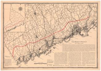
DescriptionPocket map with Hartford and West Hartford, Connecticut on one side and Connecticut on the other. The Hartford/West Hartford map shows local streets and parks. There is a street index at the bottom. The Connecticut map shows state, township and country roads. Towns are marked with black circles. Physical features depicted include lakes and elevation, conveyed with triangles that represent hills. There are two inset maps on the left side, one that depicts the New England states and show distances in miles between towns in the region, and the other that shows western Connecticut and eastern New York State. The maps are folded into a guide to Hartford-area bus transportation to points in Connecticut and New York City. The guide also contains advertisements and photographs of Connecticut tourist attractions.
Label TextThe Guyde Publishing Company published travel guides with such titles as Motor Trips through New England, and Train and Trolley Trips, encouraging travelers to take advantage of all the different modes of transportation available in early twentieth century Connecticut. While one side of this October 1945 map is a straightforward street map of Hartford and the other side is a straightforward road map of Connecticut, the accompanying guidebook provides local and long distance bus schedules, train schedules, and information on air travel. A flight from Brainard Field to New York took one hours and cost $7.40. The poor paper on which both the map and guide are printed may be a hold-over from wartime rationing. World War II had ended in August and the nation was not yet back to normal.
NotesCartographic Note: No scaleStatus
Not on view

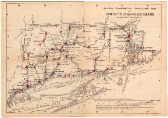
Blum's Commercial Map Publishing Company
1927-1928


Kellogg & Bulkeley
1910-1915