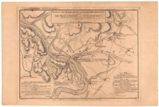
The British Invation of New Haven, July 5-6, 1779
DraftsmanDrawn by
John B. Kirby Jr.
(American)
Date1979
MediumLithography; brown printer's ink on paper
DimensionsPrimary Dimensions (image height x width): 15 x 19in. (38.1 x 48.3cm)
Sheet (height x width): 16 x 20in. (40.6 x 50.8cm)
Sheet (height x width): 16 x 20in. (40.6 x 50.8cm)
ClassificationsGraphics
Credit LineGift of John B. Kirby, Jr.
DescriptionMap of New Haven harbor, with the Mill River to the north, the East Haven Stone Church tot he east, the harbor to the south, and Hotchkisstown/Westville to the west. The map shows the movement of the British troops as they moved across through the city, the locations of specific battles, and notable landmarks involved in the invasion. The British fleet is depicted in the harbor, represented by three ships, the Camilla (frigate), Scorpion (sloop), and Halifax (brig). A list of American and British casualties is located on the right side of the map.
Object number1979.98.0
NotesCartographic Note: No scaleOn View
Not on view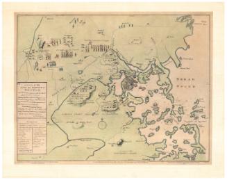

D. W. Kellogg & Co.
1830-1840