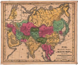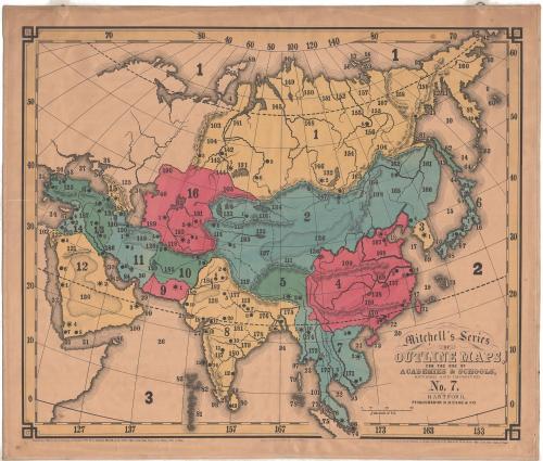
Asia
PrinterPrinted by
Bingham & Kelly
(American, 1857 - 1859)
PublisherPublished by
O. D. Case
(American, 1826 - 1903)
Date1857
MediumLithography; black printer's ink and watercolor on paper, lined with linen
DimensionsPrimary Dimensions (image height x width): 22 3/4 x 27 3/8in. (57.8 x 69.5cm)
Sheet (height x width): 24 5/8 x 29in. (62.5 x 73.7cm)
Mount (height x width): 25 1/8 x 29 3/8in. (63.8 x 74.6cm)
Sheet (height x width): 24 5/8 x 29in. (62.5 x 73.7cm)
Mount (height x width): 25 1/8 x 29 3/8in. (63.8 x 74.6cm)
ClassificationsGraphics
Credit LineMuseum purchase
DescriptionMap of Eastern Europe, the Middle East, India and the Far East. The countries are not labeled; instead, they are numbered. There are also smaller numbers and circles that correspond with a key published separately from the map. Natural features include elevation, depicted with hachure marks; deserts, depicted with clusters of dots; rivers and islands.
Object number1972.36.55.7
NotesCartographic Note: Scale: About 2 3/4 inches equals 600 miles
Constituent Note: Mitchell's Series of Outline Maps were first issued in 1841 by Mather, Case, Tiffany & Burnham of Hartford, Connecticut and Augustus Mitchell of Philladelphia.. In 1857, the maps were updated and resissued. This time the printing was done by a new lithography firm, Bingham & Kelly and the maps and the accompanying key were published by O.D. Case & Co., both in Hartford.On View
Not on view