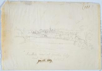
Jewett City Plan of Village
DraftsmanDrawn by
Unknown
Datebefore 1893
MediumDrawing; pencil on wove paper
DimensionsPrimary Dimensions (image height x width): 27 x 54 1/2in. (68.6 x 138.4cm)
Sheet (height x width): 30 1/2 x 54 1/2in. (77.5 x 138.4cm)
ClassificationsGraphics
Credit LineConnecticut Museum of Culture and History collection
Object number2012.312.269
DescriptionMap of Jewett City, Hopevile, and the surrounding area. The Quinebaug River and the tracks of the New York and New England Railroad are to the west. A road leading northeast towards Giles Pond is to the north. Four Corners and the property of Daniel Giles are to the east. The Pachaug River is to the south, running between the villages of Jewett City and Hopeville. Various structures are identified, including Ashland Mills, Slater Mills, a Catholic church, a depot, a hotel, and a machine shop in Jewett City; a creamery and an ice house on the east-running road; a blacksmith shop and a school in Hopeville; and a sawmill at Giles Pond. A dotted line may indicate a water main runs from Ashland Pond towards Hopeville, parallel to the road. An inscription reads "Sta. 210 + 30 on new line leading main." An arrow points north. Various calculations are at lower right.;
Label TextJewett City is a village in the town of Griswold, located at the junction of the Quinebaug and Pachaug Rivers. It is named for Eliezer Jewett who settled there in 1771 and was a farmer, tavern keeper, and ran small saw, grist, and fulling mills. In the nineteenth century, the village developed as a manufacturing community, first with cotton mills and then other industries. It prospered during the latter part of the nineteenth century. This map appears to be a preliminary study for some kind of utility, possibly a water supply system and may relate to the Jewett City Water Company, which was founded in 1894.
NotesCartographic Note: 1 inch equals 500 feetDate Note: The drawing must date from between 1873 and 1893, since the New York and New England Railroad, which appears on the map, was only in business during those years. If the map relates to Jewett City Water Company, which was founded in 1894, it probably dates to the 1890s.
Status
Not on view
Giles Bishop


W. H. Brown