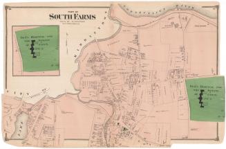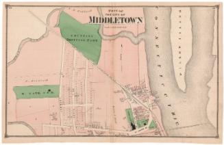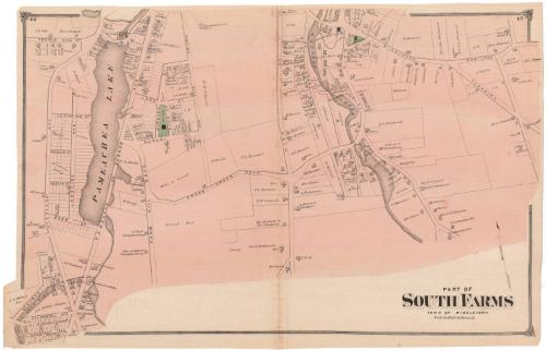
Part of South Farms, Town of Middletown
PublisherPublished by
F. W. Beers & Co.
(American)
Date1874
MediumLithography; black printer's ink and watercolor on wove paper
DimensionsPrimary Dimensions (image height x width): 14 5/8 x 23 1/8in. (37.1 x 58.7cm)
Sheet (height x width): 15 x 23 3/8in. (38.1 x 59.4cm)
ClassificationsGraphics
Credit LineMuseum purchase
Object number1980.100.7
DescriptionMap of South Farms in Middletown, Connecticut, depicting roads and land lots, labeled with the owner's name. Buildings are indicated with squares. Two schools and an Episcopalian church are colored green. Natural features include Pameachea Lake, Glen Lake, West Lake, and Sanseer Creek.
Label TextThe central portion of Middletown was incorporated as a city, while outlying areas of the township retained their separate identities. While part of the South Farms district retained its rural character well into the twentieth century, the junction of East Main Street and the Middlesex turnpike developed as a commercial center around the Russell Manufacturing Company, which made elastic webbing for the industrial belting used.to drive machinery. Other businesses that appear on this 1874 map of South Farms include the Wilcox & Company Lock Factory and the Star Tool Company Works. Stores and multiple family housing grew up around these industries. Traces of the area's more rural past remain in the ice house on Pameacha Pond, a gristmall, and several slaughterhouses. This map was originally part of an atlas published by F. W. Beers & Co.
NotesCartographic Note: Scale: 1 inch equals 20 rodsStatus
Not on view