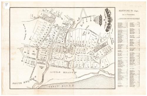
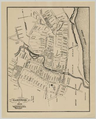
Hartford in 1640
SurveyorSurveyed by
William S. Porter
(American, about 1800 - 1866)
DraftsmanDrawn by
William S. Porter
(American, about 1800 - 1866)
PrinterPrinted by
Unknown
Dateafter 1851
MediumLithography; black printer's ink on wove paper
DimensionsPrimary Dimensions (image height x width): 16 1/8 x 12 1/2in. (41 x 31.8cm)
Sheet (height x width): 22 x 14 1/4in. (55.9 x 36.2cm)
Sheet (height x width): 22 x 14 1/4in. (55.9 x 36.2cm)
ClassificationsGraphics
Credit LineConnecticut Museum of Culture and History collection
DescriptionMap of Hartford as the city was laid out in 1640, and oriented east-west on the sheet. It extends from "Part of the Cow Pasture" to the north, the Connecticut River ("Great River" on the map) to the east, "Part of the Ox Pasture" to the south, and the West Field to the west. The Little River runs east-west to where it meets the Connecticut River. Land lots are numbered and contain a square that presumably represents the location of the building on it, and the name of the property owner and, in some cases, the name of the individual to whom it was sold. To the right of the map is an alphabetical list of freeholders and their corresponding lot numbers. The roads are not named, as such, but they are labeled with descriptions of where they come from or lead. Public spaces, such as the meeting house yard, "prison jail," and market place are included, as are roads.
Object number2012.312.210
NotesCartographic Note: No scale
Date Note: Although the map was surveyed and drawn in 1838, it apparently was not printed until 1851.On View
Not on view

Silvermine Production
1973