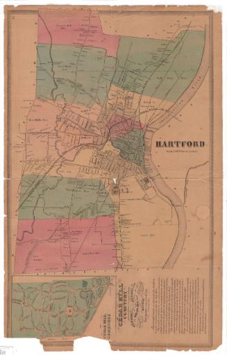
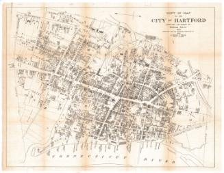
Map of the City of Hartford, Connecticut
SurveyorSurveyed by
E. C. Smith
(American)
SurveyorSurveyed by
H. E. Van Zandt
(American)
PrintmakerLithographed by
William H. Rease
(American, 1818 - after 1860)
PrinterPrinted by
William H. Rease
(American, 1818 - after 1860)
PublisherPublished by
Eneas Smith
(American)
Date1859
MediumLithography; black printer's ink and watercolor on paper
DimensionsPrimary Dimensions (image height x width): 56 x 53 1/2in. (142.2 x 135.9cm)
Sheet (height x width): 58 x 54 3/8in. (147.3 x 138.1cm)
ClassificationsGraphics
Credit LineConnecticut Museum of Culture and History collection
Object number2012.312.175
DescriptionStreet map of Hartford, Connecticut, extending from Spring Grove Cemetery to the north, to the Connecticut River to the east, to Wawarme Avenue to the south, and Sigourney Street to the west. The city's wards are labeled on the map. Buildings and their lot numbers are given, with different types of shading for different uses. Notable landmarks include cemeteries; Bushnell and other parks; Trinity College; the Hartford and New Haven; Hartford, Providence and Fishkill; and the Hartford and Springfield Railroads and Union Station. In the top right corner, there is an inset map of Hartford in 1640, and just below it, a map of Hartford school districts. The map is framed with a decorative border of stylized leaves.
Label TextAt a meeting of the Hartford Common Council in December 1858, a "communication was received from Eneas Smith, proposing to furnish a new map and survey of the town of Hartford, drawn on a scale of 250 feet to the inch, for $160." The Council voted "to engage Mr. Smith to make a survey and map as proposed, provided the expense does not exceed $160." The survey was evidently conducted and the map prepared with lightning speed; copies were offered for sale by the Hartford printer William James Hamersley as early as May 1859. This map should not be confused with Marcus Smith's 1850 map of Hartford, which was frequently referred to by later mapmakers and historians to illustrate the growth of the city and which was popularly known as "Smith's map."
NotesCartographic Note: Scale: 1 inch equals 250 feetStatus
Not on view