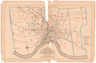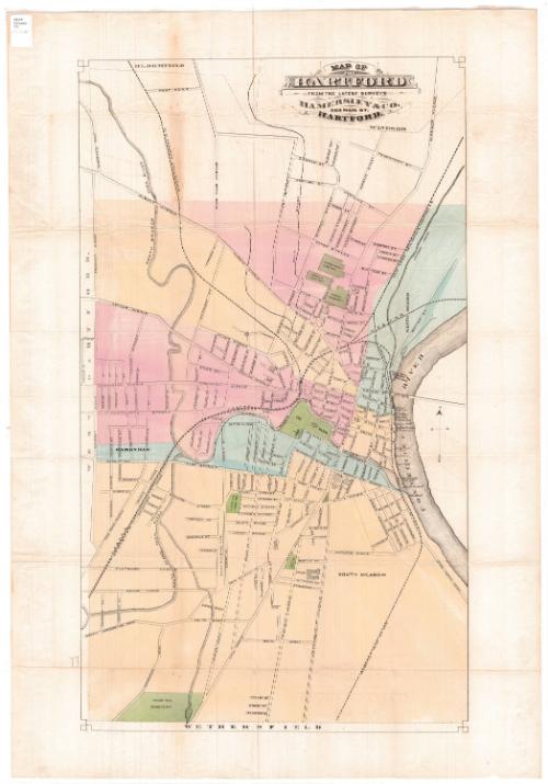
Map of Hartford
PrinterPrinted by
Hamersley & Co.
(American, 1868 - 1877)
Dateafter 1871
MediumLithography; black printer's ink and watercolor on wove paper
DimensionsPrimary Dimensions (image height x width): 31 x 18in. (78.7 x 45.7cm)
Sheet (height x width): 35 1/4 x 24 1/2in. (89.5 x 62.2cm)
ClassificationsGraphics
Credit LineConnecticut Museum of Culture and History collection
Object number2012.312.189
DescriptionStreet map of Hartford, Connecticut, from the town lines of Bloomfield and Windsor to the north, the Connecticut River to the east, the town line of Wethersfield to the south, and the town line of West Hartford to the west. Different sections of the city, probably wards, have been colored pale yellow, pink or blue. Green represents cemeteries and parks. The Connecticut Valley; New York, New Haven and Hartford; and Hartford, Providence and Fishkill Railroads run through the city.
Label TextIn this map of high Victorian Hartford, the city that Mark Twain knew appears surprisingly small and compact, with a network of railroad lines surrounding the city center and numerous cemeteries and "the Park" (the future Bushnell Park) providing much-needed green space. It is likely that neither the Connecticut State Capitol building nor the new Post Office behind the Old State House (both of which are pictured on the map) were completed when this map was published. Both structures were projected, and both projects required several years for completion. The mapmaker likely included these prominent landmarks because otherwise the map would have been immediately outdated. An 1877 birds-eye view by O. H. Bailey shows the city at approximately the same point in time and makes an interesting comparison.
NotesCartographic Note: No scaleDate Note: The map includes a depiction of the Connecticut State Capitol that does not correspond to the building as constructed. This suggests that the map predates the completion of the building and probably dates from the period of the design competition, 1871-1872.
Status
Not on view