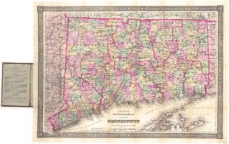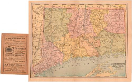
Connecticut
PublisherPublished by
George F. Cram & Co.
American, 1869 - 2012
DistributorDistributed by
Brown Thomson & Co.
American
Dateabout 1909
MediumLithography; black and colored printer's inks on wove paper, in paper covers
DimensionsPrimary Dimensions (image height x width): 10 1/4 x 13in. (26 x 33cm)
Sheet (height x width): 11 1/8 x 14in. (28.3 x 35.6cm)
Sheet (height x width): 11 1/8 x 14in. (28.3 x 35.6cm)
ClassificationsGraphics
Credit LineConnecticut Museum of Culture and History collection
DescriptionPocket map of Connecticut, with Massachusetts to the north, Rhode Island to the east, part of Long Island and the Long Island Sound to the south, and New York to the west. The state is divided into counties, colored green, pink, orange, or yellow. Cities and towns are marked with open circles and are labeled. Railroad lines, including stations, are shown: New York, New Haven and Hartford; New York and New England; Central Vermont; and Philadelphia, Reading and New England. Physical features depicted include rivers and lakes/ponds.
Object number1991.196.0
MarkingsVerso, center, stamped in blue ink: "CtHi"InscribedFront cover, printed in black ink: "POCKET MAP / OF / CONNECTICUT. / COMPLIMENTS OF / Brown, Thomson & Co."Inside cover, top left, handwritten in pencil: "Maps / 90664"
[Advertisements for B. Shoninger & Co; Brown, Thomson & Co.]
Recto, bottom right, printed in black ink: "CONNECTICUT / The Geo. F. Cram Pub. Co. / Engravers & Publishers, / CHICAGO ILL."
Verso, center, handwritten in pencil: "90664"
NotesCartographic Note: Scale: 1 1/4 inches equals 10 miles
Collections
- Maps and Charts: Finding Your Place in Connecticut History
On View
Not on view