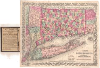
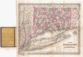
Connecticut
PrintmakerEngraved by
Unknown
PublisherPublished by
Unknown
DateProbably 1807
MediumEngraving; black printer's ink and watercolor on wove paper, in cardboard covers
DimensionsPrimary Dimensions (image height x width): 7 1/4 x 9 1/8in. (18.4 x 23.2cm)
Sheet (height x width): 8 1/2 x 10 1/4in. (21.6 x 26cm)
Sheet (height x width): 8 1/2 x 10 1/4in. (21.6 x 26cm)
ClassificationsGraphics
Credit LineConnecticut Museum of Culture and History collection
DescriptionPocket map of the state of Connecticut, with Massachusetts to the north, Rhode Island to the east, part of Long Island and the Long Island Sound to the south, and New York to the west. The state is divided into counties, colored pink, green, yellow or blue. Main roads are depicted, as are railroads, including the New York and New Haven; Naugatuck; Housatnoic; New Haven and Northampton; Hartford and Profidence; and Willimantic to Palmer Railroads. Physical features depicted include elevation, conveyed with hachure marks; rivers; and lakes.
Object number1986.290.0
MarkingsVerso, lower left, stamped in blue ink: "CtHi"InscribedRecto, left side, handwritten in pencil: "Maps / 86852"Bottom right, printed in black ink: "CONNECTICUT"
Verso, lower left, handwritten in pencil: "086852"NotesCartographic Note: Scale: 1 inch equals about 10 1/2 miles
Collections
- Maps and Charts: Finding Your Place in Connecticut History
On View
Not on view