Map of Connecticut
PrintmakerLithographed by
Kellogg & Bulkeley
American, 1867 - 1990
PublisherPublished by
Hamersley & Co.
American, 1868 - 1877
Date1875
MediumLithography; black printer's ink and watercolor on wove paper, in cardboard covers
DimensionsPrimary Dimensions (image height x width): 17 7/8 x 23in. (45.4 x 58.4cm)
Sheet (height x width): 19 1/2 x 27 1/2in. (49.5 x 69.9cm)
Sheet (height x width): 19 1/2 x 27 1/2in. (49.5 x 69.9cm)
ClassificationsGraphics
Credit LineConnecticut Museum of Culture and History collection
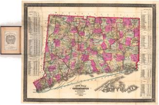
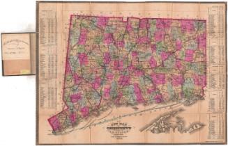
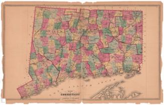
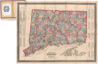
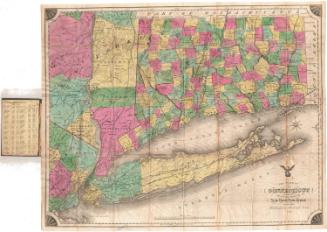
DescriptionPocket map of Connecticut, with the border of Massachusetts to the north, Rhode Island to the east, part of Long Island and the Long Island Sound to the south, and New York to the west. The state is divided into counties, outlined in red, and towns, colored blue, green, yellow, pink or peach. Roads and railroads are shown, including the Danbury and Norwalk; Housatonic; New Haven and Northampton; Air Line; New Haven, Hartford and Springfield; Western; Connecticut Valley; New London Northern; and Norwich and Worcester Railroads. Included with the map is a booklet listing the towns in each county and their populations for the 1860 and 1870 census.
Object number1949.20.2
InscribedFront cover, center, gold tooled: "CONNECTICUT"Recto, booklet, printed in black ink: "A POCKET MAP / OF / CONNECTICUT, / With a List of all the Towns arranged by Counties, / AND / NUMBER OF INHABITANTS / BY / THE LAST TWO CENSUS. / HARTFORD: / HAMERSLEY & COMPANY, / Publishers, Booksellers, and Stationers, / 263 Main Street. / 1875."
Recto, map, top left, handwritten in red ink: "57497"
Bottom center, printed in black ink: "MAP / OF / CONNECTICUT / BY / HAMERSLEY & CO / Publishers HARTFORD / Scale 4 1/2 Miles to an Inch / Kellogg & Bulkeley Lith. Hartfd. Con"NotesCartographic Note: Scale: 1 inch equals 4 1/2 miles
Date Note: Although the booklet accompanying the map is dated 1875, and the map was apparently published in that year, it does not include the town of Newington, incorporated in 1871, and Thomaston, incorporated in 1875, still appears as Plymouth Hollow.
Collections
- Maps and Charts: Finding Your Place in Connecticut History
On View
Not on view