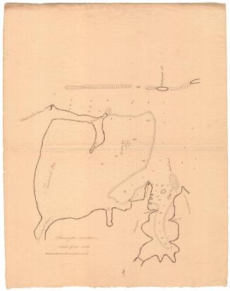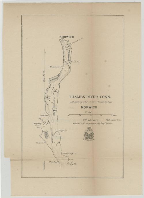
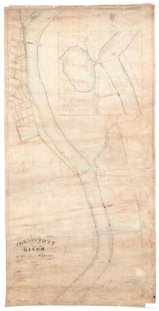
Thames River, Connecticut, showing the obstructions below Norwich
SurveyorSurveyed by
Unknown
PrinterPrinted by
Unknown
Dateabout 1910
MediumLithography; black printer's ink on wove paper
DimensionsPrimary Dimensions (image height x width): 9 x 5 11/16in. (22.9 x 14.4cm)
Sheet (height x width): 10 3/4 x 7 5/8in. (27.3 x 19.4cm)
Sheet (height x width): 10 3/4 x 7 5/8in. (27.3 x 19.4cm)
ClassificationsGraphics
Credit LineMuseum purchase
DescriptionChart of the Thames River below Norwich, Connecticut, showing water depth, water curves, sandbars, coves, points, shoals and flats. The Shetucket River is located to the southeast of Norwich. Below the title is the seal and motto of the Army Corps of Engineers, featuring the Corps Castle with three towers, and the French word "essayons," or "let us try."
Object number1982.129.3
MarkingsRecto, top left corner, printed in black ink on sticker: "MAP BOX 139"Verso, center, stamped in blue ink: "CtHi"
Center, stamped in blue ink: "THE CONNECTICUT / 82004 / HISTORICAL SOCIETY"InscribedRecto, right side, printed in black ink: "THAMES RIVER CONN. / showing the obstructions below / NORWICH"
Right side, printed in black ink: "Reduced and Engraved in the Engr. Bureau"
Verso, top left, handwritten in pencil: "Map Box / 139"
Top, handwritten in pencil: "Deacidified / 3/12/02"
Bottom left, handwritten in pencil: "MAP BOX / 139"NotesCartographic Note: Scale: 2 3/8 inches equals 1 mile
Constiuent Note: The "Engraving Bureau" whose imprint appears on this map may have been a federal agency.
Medium Note: The print is probably a transfer lithograph, even though there is an inscription that says it was engraved.
Collections
- Maps and Charts: Finding Your Place in Connecticut History
On View
Not on view
George W. Corliss