Skip to main content
Collections
People
Favorites
Advanced Search
Search
Objects
(40)
Close
Refine Results
Classification(s)
Graphics
(805)
Equipment
(1)
Hardware
(1)
Collections
*
Maps and Charts: Finding Your Place in Connecticut History
(807)
Kellogg Brothers Lithographs
(1)
Date
to
Department
Visual Collections
(807)
Image Available
On View
Sort:
Relevance
Title (A–Z)
Date (Older First)
Object number (Ascending)
Last Updated (Ascending)
List
Images
Table
Filters
View PDF
807 results for
*
Result type
Objects
People
Maps and Charts: Finding Your Place in Connecticut History
Clear All Filters
Image Not Available
for Map of New Britain Connecticut
Map of New Britain Connecticut
Walker Lithograph and Publishing Company
1904-1912
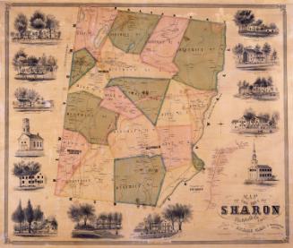
Map of the Town of Sharon, Litchfield Co. Conn.
Lawrence Fagan
1853
Image Not Available
for Map of West Middle School District
Map of West Middle School District
Unknown
Possibly 1871
Image Not Available
for Map of Connecticut
Map of Connecticut
Connecticut Department of Transportation
1971
Map of the Towns of Saybrook and Old Saybrook, Middlesex County, Connecticut
E. M. Woodford
1853
Image Not Available
for Pitner's Map of Greater Hartford and New Britain
Pitner's Map of Greater Hartford and New Britain
Carl Pitner
Possibly 1937
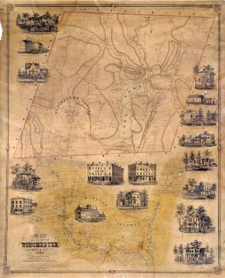
Map of the Town of Winchester, Litchfield County, Conn.
E. M. Woodford
1852
Image Not Available
for Map of the United States
Map of the United States
James H. Young
after 1840
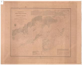
Harbors of Sheffield Island and Cawkins Island
United States Coast Survey
1848
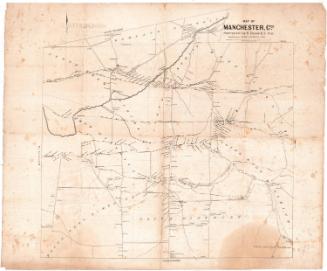
Map of Manchester, Conn.
Eli Bissell
1849
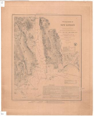
The Harbor of New London
United States Coast Survey
1848
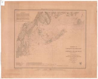
Harbors of Captain's Island East and Captain's Island West
United States Coast Survey
1849
Image Not Available
for Map of the State of Connecticut
Map of the State of Connecticut
J. B. Beers & Co.
1884
Image Not Available
for Railroad map of Massachusetts, Connecticut and Rhode Island
Railroad map of Massachusetts, Connecticut and Rhode Island
J. T. Powers & Co.
1852-1860
Image Not Available
for Hartford County, Connecticut
Hartford County, Connecticut
United States Geological Survey
1974
Image Not Available
for Map of the State of Connecticut
Map of the State of Connecticut
J. B. Beers & Co.
1885
Image Not Available
for Talcott Mountain Forest Protective Association
Talcott Mountain Forest Protective Association
Talcott Mountain Forest Protective Association
1933
Image Not Available
for New London County, Connecticut
New London County, Connecticut
United States Geological Survey
1979
Image Not Available
for New Haven County, Connecticut
New Haven County, Connecticut
United States Geological Survey
1980
Image Not Available
for Litchfield County, Connecticut
Litchfield County, Connecticut
United States Geological Survey
1979
Image Not Available
for South half, Fairfield County, Connecticut
South half, Fairfield County, Connecticut
United States Geological Survey
1980
Image Not Available
for North half, Fairfield County, Connecticut
North half, Fairfield County, Connecticut
United States Geological Survey
1979
Image Not Available
for Map of Windham County Connecticut
Map of Windham County Connecticut
W. C. Eaton
1856
Image Not Available
for Map of the United States of America, the British Provinces, Mexico, the West Indies and Central America with part of New Grenada and Venezuela
Map of the United States of America, the British Provinces, Mexico, the West Indies and Central America with part of New Grenada and Venezuela
George W. Colton
1852
Next Page