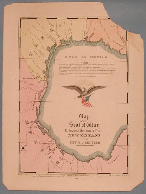
Map of the Seat of War, Embracing the Country from New Orleans to the City of Mexico.
PrinterPrinted by
E.B. & E.C. Kellogg
(American, 1840 - 1867)
PublisherPublished by
E.B. & E.C. Kellogg
(American, 1840 - 1867)
PublisherPublished by
Kelloggs & Thayer
(American, 1846 - 1847)
PublisherPublished by
D. Needham
(American, 1808 - 1888)
Date1846
MediumLithography; printer's ink and watercolor
DimensionsPrimary Dimensions (image height x width): 13 1/4 x 9 1/4in. (33.7 x 23.5cm)
Sheet (height x width): 15 15/16 x 11 7/8in. (40.5 x 30.2cm)
Mount (height x width): 15 15/16 x 11 7/8in. (40.5 x 30.2cm)
ClassificationsGraphics
Credit LineGift of Samuel St. John Morgan
Object number1948.13.35
DescriptionMap includes Louisiana, Texas, and the Mexican states of Tamaulipas, Vera Cruz, and Yucatan. The locations of the American Camp, and the cities of New Orleans, Galveston, Matamoras, Tampico, City of Mexico, Jalapa, and Vera Cruz are indicated. The title, a lengthy note, and a flying eagle holding an American flag are inscribed within the Gulf of Mexico.
Label TextThis odd map depicts the coast of the Gulf of Mexico in an almost circular format. Published in 1846, at the outbreak of the Mexico War, perhaps it was intended to stress the proximity of the battlegrounds, not only to Texas, which had only become a state in 1845, but also to New Orleans, which had been part of the Union since 1812. The patriotic purpose of the map is underscored by the central eagle which is shown flying towards the Mexican coast, holding an American flag.
Status
Not on view


Jampa Tsondue
2018 March 10