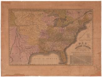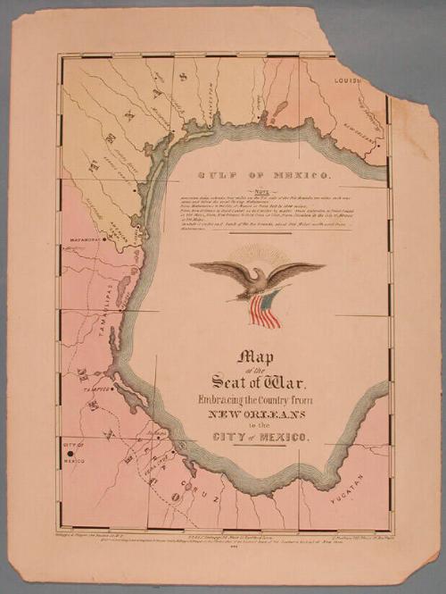
Map of the Seat of War, Embracing the Country from New Orleans to the City of Mexico.
PrinterPrinted by
E.B. & E.C. Kellogg
(American, 1840 - 1867)
PublisherPublished by
E.B. & E.C. Kellogg
(American, 1840 - 1867)
PublisherPublished by
Kelloggs & Thayer
(American, 1846 - 1847)
PublisherPublished by
D. Needham
(American, 1808 - 1888)
Date1846
MediumLithography; printer's ink and watercolor
DimensionsPrimary Dimensions (image height x width): 13 1/4 x 9 1/4in. (33.7 x 23.5cm)
Sheet (height x width): 15 15/16 x 11 7/8in. (40.5 x 30.2cm)
Mount (height x width): 15 15/16 x 11 7/8in. (40.5 x 30.2cm)
Sheet (height x width): 15 15/16 x 11 7/8in. (40.5 x 30.2cm)
Mount (height x width): 15 15/16 x 11 7/8in. (40.5 x 30.2cm)
ClassificationsGraphics
Credit LineGift of Samuel St. John Morgan
DescriptionMap includes Louisiana, Texas, and the Mexican states of Tamaulipas, Vera Cruz, and Yucatan. The locations of the American Camp, and the cities of New Orleans, Galveston, Matamoras, Tampico, City of Mexico, Jalapa, and Vera Cruz are indicated. The title, a lengthy note, and a flying eagle holding an American flag are inscribed within the Gulf of Mexico.
Object number1948.13.35
On View
Not on view