Connecticut Highways, 1942
PublisherPublished by
Connecticut State Highway Department
(American, 1895 - 1969)
Date1942
Mediumpaper
DimensionsPrimary Dimensions (overall height x width): 20 1/2 × 31 1/4in. (52.1 × 79.4cm)
ClassificationsGraphics
Credit LineGift of Thomas Palshaw
Object number2014.112.3
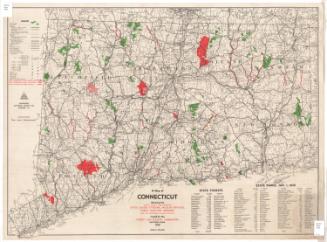
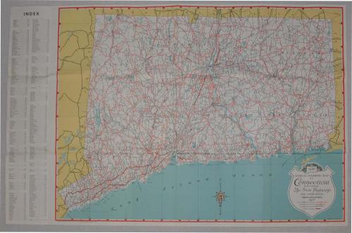
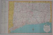
DescriptionMap of Connecticut highways in 1942, distributed by the Connecticut State Highway Department. One side is a color map of the state highways and other roads. The background of the state outline is white, and the surrounding states are yellow. The roadways are indicated in red. There is an index on the left side of the map indicating the location of Connectict towns.
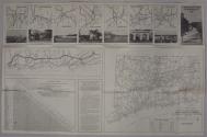
On the reverse side, there is a black and white map on the bottom right showing the locations of the state police barracks, state parks and forests, and highway first aid stations. This map has a key to the state police telephone numbers. Across the top of the page are seven black and white photos are select towns and a close up view of those cities. The cities are: Hartford, Waterbury, Danbury, New London, Norwich, Bridgeport, and New Haven. Beneath these photos on the left hand side of the page is a black and white map close up of the Merritt Parkway and Long Island Sound. On the bottom left of the page is a mileage table showing approximate distances between points in Connecticut. Next to the table on the right, regulations concerning speed and manner of driving are listed.
NotesWith the two photographs, highway map, and badge came papers related to the Hartford Aviation Commission, which can be found in the archives collection with object number Ms 101882.On the reverse side, there is a black and white map on the bottom right showing the locations of the state police barracks, state parks and forests, and highway first aid stations. This map has a key to the state police telephone numbers. Across the top of the page are seven black and white photos are select towns and a close up view of those cities. The cities are: Hartford, Waterbury, Danbury, New London, Norwich, Bridgeport, and New Haven. Beneath these photos on the left hand side of the page is a black and white map close up of the Merritt Parkway and Long Island Sound. On the bottom left of the page is a mileage table showing approximate distances between points in Connecticut. Next to the table on the right, regulations concerning speed and manner of driving are listed.
Status
Not on view