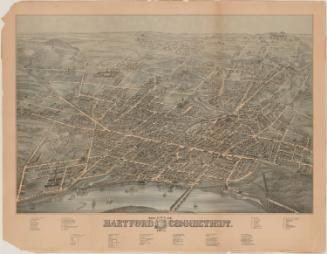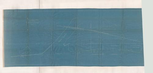
Plan of Riverfront at Hartford, Ct. showing proposed new dock line between Gas Dock and Colt's Dock
SurveyorSurveyed by
Henry J. Blakeslee
(American, 1876 - 1941)
DraftsmanDrawn by
Henry J. Blakeslee
(American, 1876 - 1941)
Date1905
MediumBlueprint; cyanotype on paper
DimensionsPrimary Dimensions (image height x width): 17 1/2 x 46 1/4in. (44.5 x 117.5cm)
Sheet (height x width): 18 3/4 x 48in. (47.6 x 121.9cm)
Sheet (height x width): 18 3/4 x 48in. (47.6 x 121.9cm)
ClassificationsGraphics
Credit LineGift of the Middlesex County Historical Society
DescriptionPlan shows a section of the Hartford waterfront near the confluence of the Park River with the Connecticut River. The line of the Valley Division of the New York, New Haven and Hartford Railroad, with a bridge across the Park River, and the property of the Hartford and New York Transportation Company, the so-called Gas Dock, are shown. Also shown are Colt's Dock, a "dock for unloading stone," the proposed Hartford Electric Light Company Dock,and the Dutch Point power station of the Hartford Electric Light Company.
Object number2014.87.4
NotesSubject Note: Henry J. Blakeslee went to work for the Hartford Electric Light Company immediately following graduation from Trinity College. (Finlay 6/4/2014)On View
Not on view
O.H. Bailey and Company