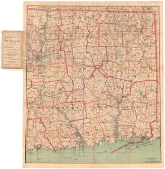
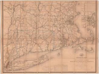
Map of Connecticut, Western Part
PublisherPublished by
Geo. H. Walker & Co.
(American, founded 1880)
Date1893
MediumLithography; black and colored printer's inks on wove paper, lined with linen
DimensionsPrimary Dimensions (image height x width): 40 1/4 x 27 1/2in. (102.2 x 69.9cm)
Sheet (height x width): 40 3/4 x 27 5/8in. (103.5 x 70.2cm)
Mount (height x width): 40 3/4 x 27 5/8in. (103.5 x 70.2cm)
ClassificationsGraphics
Credit LineConnecticut Museum of Culture and History collection
Object number2004.165.0
DescriptionMap of the western part of Connecticut extending to New Britain to the east. The eastern portion of New York along the Connecticut border to Unionville is also shown. The state is divided into counties and towns. Transportation infrastructure is prominently depicted on the map, with roads, railroads and cycling routes depicted. The railroad lines shown include the New York, New Haven and Hartford; the Shepaug, Litchfield and New England; New York and New England; and the Reading Railroad System, New England Division. Cycling routes are shown in red and are on roads. Physical features depicted include elevation, conveyed with contour lines; rivers; lakes; marshes; and islands.
Label Text"Cycling Routes" are "shown in red," on this large-scale map of western Connecticut, suggesting that it was intended primarily for use by bicyclists. The map also suggests that late-nineteenth-century bicycle riders covered a great deal of ground on their "wheels." Maps like this were useful for cyclists because not all of the existing roads were suitable for bicycle riding. Outside major cities, most roads were dirt or gravel, and these surfaces could prove difficult to negotiate on the bicycles of the day. Even before automobiles became common, bicyclists began demanding road improvements and they were apparently numerous enough and vocal enough so that their demands were heard.
NotesCartographic Note: Scale: 1 inch equals almost 2 milesStatus
Not on view
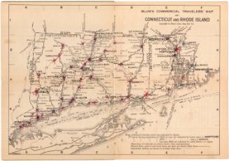
Blum's Commercial Map Publishing Company
1927-1928