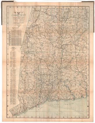
The Heart of New England
PublisherPublished by
The Bullard Company
(American, 1909 - 1915)
Date1914
MediumLithography; black and blue printer's ink on wove paper, in cardboard covers
DimensionsPrimary Dimensions (side a, image height x width): 43 1/2 x 37 5/8in. (110.5 x 95.6cm)
Sheet (height x width): 45 1/2 x 38 3/4in. (115.6 x 98.4cm)
Primary Dimensions (side by, image height x width): 42 1/4 x 31in. (107.3 x 78.7cm)
Sheet (height x width): 45 1/2 x 38 3/4in. (115.6 x 98.4cm)
ClassificationsGraphics
Credit LineConnecticut Museum of Culture and History collection
Object number2004.163.0
DescriptionTwo-sided map, with one side depicting part of southern New England, with New Hampshire to the north, the Atlantic Ocean to the west, Voluntown, Connecticut to the south. Maine, Vermont, northern New Hampshire, and the western and southern parts of Connecticut and Rhode Island are not shown. The map shows through roads, "good roads," local and private roads, and churches, schools, cemeteries, town halls, and light houses. Steam and electric railroad lines are also depicted, as are railroad stations. Altitude, presumably in feet, is given numerically.
On the other side is a map of part of the Connecticut River Valley, from the border of Vermont to the north, New London County, Connecticut to the east, the Long Island Sound to the south, and the border of New York to the west. The map shows through roads, "good roads," local and private roads, and churches, schools, cemeteries, town halls, and light houses. Steam and electric railroad lines are also depicted, as are railroad stations. Altitude, presumably in feet, is given numerically. On the left side is a distance chart and below that are population tables for the cities and towns of Massachusetts and Connecticut that are shown on this side of the map. On the right side are 1910 population lists for the towns and cities of Massachusetts, Rhode Island, Connecticut, and New Hampshire that are depicted on the other side of the map.
On the other side is a map of part of the Connecticut River Valley, from the border of Vermont to the north, New London County, Connecticut to the east, the Long Island Sound to the south, and the border of New York to the west. The map shows through roads, "good roads," local and private roads, and churches, schools, cemeteries, town halls, and light houses. Steam and electric railroad lines are also depicted, as are railroad stations. Altitude, presumably in feet, is given numerically. On the left side is a distance chart and below that are population tables for the cities and towns of Massachusetts and Connecticut that are shown on this side of the map. On the right side are 1910 population lists for the towns and cities of Massachusetts, Rhode Island, Connecticut, and New Hampshire that are depicted on the other side of the map.
Label TextThis two-sided map was evidently intended for use as a road map by bicyclists and early automobile drivers. Both groups had been lobbying for improvements to existing roads, which had originally been designed for use by horse-drawn vehicles and which often proved inadequate for bicycles and cars. The "good roads" movement in the early part of the twentieth century was a direct result of their efforts. By 1920, the New England states would have some of the best roads in the nation.
NotesCartographic Note: Scale, side a: 1 inch equals 2 1/2 miles; side b: 1 inch equals 3 milesStatus
Not on view