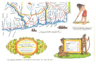
The Map of Pioneer Hartford, Showing Early Landmarks and the Locations of Historical Events
MakerMade by
James Goldie
(American, 1890 - 1986)
MakerMade by
Ruth Frances Rising
(American, 1901 - 1948)
Date1927
MediumLithography; black printer's ink and hand coloring on wove paper
DimensionsPrimary Dimensions (image height x width): 6 5/8 x 8 7/8in. (16.8 x 22.5cm)
Sheet (height x width): 7 x 9in. (17.8 x 22.9cm)
Sheet (height x width): 7 x 9in. (17.8 x 22.9cm)
ClassificationsGraphics
Credit LineGift of the University of Hartford
DescriptionMap of Hartford, Connecticut, oriented east-west with the Connecticut River appearing at the bottom. Through pictures, the map shows the locations of historic places and happenings of events that occurred in the seventeenth century. Those depictions of historic events are annotated with textual descriptions of what happened and when. On the left side of the map is a picture of John Winthrop, the first governor of Connecticut, and on the right is a picture of Thomas Hooker with a depiction of "the adoption of the Fundamental Orders." In the top left corner is a seal of Hartford, featuring the Latin phrase "sigilium civitatis Hartfordiensis" and a man fishing with a net in front of a tree. The cartouche includes the official seal of Hartford, which depicts an eagle atop a shield with a deer on it and a grapevine at the bottom, below which is the Latin phrase "post nubila phoebus."
Object number2004.161.1
NotesCartographic Note: No scaleOn View
Not on view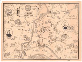
James Liddell Goldie
1927