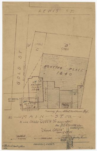
Old Mill Property Purchases and Mill Locations
Date20th century
MediumDrawing; black and blue ink and pencil on wove paper
DimensionsPrimary Dimensions (image height x width): 8 3/8 x 10 7/8in. (21.3 x 27.6cm)
Sheet (height x width): 8 3/8 x 10 7/8in. (21.3 x 27.6cm)
ClassificationsGraphics
Credit LineConnecticut Museum of Culture and History collection
Object number2004.160.0
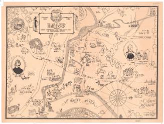
DescriptionMap of what is probably Manchester, Connecticut, depicting George and Timothy Cheney's land purchases and the locations of the saw, silk and grist mills, distillery, and homestead. The names of the original landowners and the dates of sale are provided. Blue lines represent Hop Brook.
Label TextAlthough this map records property transactions of the Cheney family of Manchester, Connecticut dating between 1783 and 1847, the map itself is clearly much later in date and was probably compiled by a historian or genealogist sometime in the twentieth century. A clue to its late date, besides the paper and style of lettering, is the note which states that "Present Roads and Mills shown by light lines." The Cheney Brothers Silk Manufacturing Company was the major employer in Manchester during the late nineteenth and early twentieth centuries.
NotesCartographic Note: Scale: 1 inch equals 200 feetStatus
Not on view
James Liddell Goldie
1927