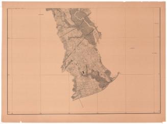
New Haven, New Haven County, Connecticut
PublisherPublished by
American Guide Co.
(American)
Dateprobably before 1887
MediumLithography; black printer's ink on wove paper
DimensionsPrimary Dimensions (image height x width): 9 3/4 x 7 3/4in. (24.8 x 19.7cm)
Sheet (height x width): 10 1/2 x 9in. (26.7 x 22.9cm)
Sheet (height x width): 10 1/2 x 9in. (26.7 x 22.9cm)
ClassificationsGraphics
Credit LineThe Connecticut Historical Society collection
DescriptionMap of New Haven, Connecticut, with City Hall at the center, Whitneyville to the north, East Haven to the east, the harbor to the south, and Allingtown to the west. Concentric circles in one-mile increments radiate out from City Hall. City streets are labeled, and a few of the buildings of Yale College are shown, as are City Hall and the prison. The New York, New Haven and Hartford; New Haven and Derby; New Haven and Northampton; and the New York and Boston Air Line Railroads runs through town. Horse railroad lines are labeled on the streets they ran along and include the Fairhaven and Westville, Cedar Hill, New Haven and Whitneyville, New Haven and Centerville Horse Railroads. Physical features include elevation, conveyed with hachure marks, and the West, Coye and Quinnipiac Rivers. On the back is a street index.
Object number2004.158.0
NotesCartographic Note: No scale
Date Note: The map must date from after 1872, the year that New York, New Haven and Hartford Railroad was established, and probably dates from before 1887, the year Yale College became Yale University. However, one of the railroad lines is identified as the "old route" of the Shore Line Railroad, and that railroad apparently was relocated in the 1890s, so it is possible that the map is slightly later than 1887.On View
Not on view


R. A. Welcke Offset Co.
probably 1967