
Map of Hartford Area, Connecticut
After a work byAfter a work by
United States Geological Survey
(American, founded 1879)
SurveyorGeology, groundwater conditions and forest boundaries by
Arthur J. Ellis
(American, died 1921)
PrinterPrinted by
A. Hoen & Company
(American, founded 1848)
PublisherPublished by
United States Geological Survey
(American, founded 1879)
Date1915
MediumLithography; black and colored printer's inks on wove paper
DimensionsPrimary Dimensions (image height x width): 22 1/8 x 19 3/8in. (56.2 x 49.2cm)
Sheet (height x width): 25 x 21 1/8in. (63.5 x 53.7cm)
ClassificationsGraphics
Credit LineConnecticut Museum of Culture and History collection
Object number2004.157.1
DescriptionMap of Hartford, Connecticut, and the surrounding area, from Windsor Locks to the north, the town line of Bolton and the Tolland County line to the east, Rocky Hill to the south, and Farmington and Simsbury to the west. Colors, lines and symbols are used to denote boulder clay or till, rock outcroppings, elevation, woods, ground water, dug or driven wells, drilled wells, and springs. There are numbers next to the wells and springs that correspond to numbers used in tables (not provided). Blue is used to denote water, including rivers, reservoirs, lakes and ponds. City streets are shown, with black squares and dots probably representing buildings. The New York, New Haven and Hartford; New England and Western; and New York and New England Railroads are shown.
Label TextUntil the end of the nineteenth century, most maps did a very poor job of expressing the height and steepness of hills and mountains. Generally this was expressed by "hachure marks," an artistic convention that indicated the presence of rough terrain, but only in a very imprecise fashion. Contour intervals, developed in the second half of the nineteenth century, provided a very accurate way to depict elevation. On this map, for example, the contour interval is twenty feet, meaning that the lines indicating elevation are twenty vertical feet apart. If the lines are very close together, the terrain will be very steep; if they are far apart, the incline is much more gradual. Look for the steep cliffs on Talcott Mountain on the west side of the Connecticut River; this height of land marks the western boundary of the Connecticut River watershed in this area. Then look at the eastern side of the river, where the hills rise more gradually. This map also provides a great deal of information about the nature of the soil and the presence (or absence) of forests in this highly developed part of Connecticut in the early part of the twentieth century.
NotesCartographic Note: Scale: 1:62,500Status
Not on view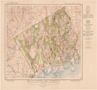

Matthews-Northrup Company
1913
