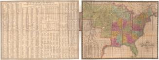
Map of the United States of America with its Territories.including also a part of Upper and Lower Canada and Mexico.
PublisherPublished by
Reed & Barber
(American, founded 1837)
Date1842
MediumEngraving; black printer's ink and watercolor on wove paper mounted on fabric
DimensionsPrimary Dimensions (image height x width): 28 x 42 1/4in. (71.1 x 107.3cm)
Sheet (height x width): 30 5/8 x 45in. (77.8 x 114.3cm)
ClassificationsGraphics
Credit LineMuseum purchase
Object number1967.111.0
DescriptionMap of the United States with part of Canada to the north, the Atlantic Ocean to the east, the Gulf of Mexico and part of Mexico to the south, and the Pacific Ocean to the west. The northern boundary of the western United States is shown at 49 degrees north latitude. Principle rivers, lakes, mountains, towns, and cities are shown. Elevation is indicated by hachure marks. Larger states are subdivided into counties. Names of Indian tribes inhabiting Indian Territory and other areas are indicated. Tables show distances between principle cities and towns and the population of the states according to the 1840 Census, divided into whites, "free colored," and slaves.
Label TextTexas was not yet a state and gold had not yet been discovered in California when this map of the United States was published in Hartford, Connecticut in 1842. The northern boundary between the United States and Canada was still under dispute, though it is shown here at 49 degrees north latitude. The population of Connecticut was 309, 978, including 289,641 whites, 8047 "free colored", and twenty-three slaves. While the Act of 1784 had provided that slaves born after 1784 would be free at the age of twenty-five, and the Act of 1797 reduced that age to twenty-one, slavery would not be formally abolished in Connecticut until 1848. This 1842 Reed & Barber should be compared with a second Reed & Barber map in the Connecticut Historical Society's collection. This later map, published in 1854, reflects the great changes that took place in the nation in just twelve years.
NotesCartographic Note: One and one half inches equals 100 milesStatus
Not on view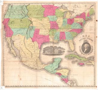


Thayer, Bridgman & Fanning
1853