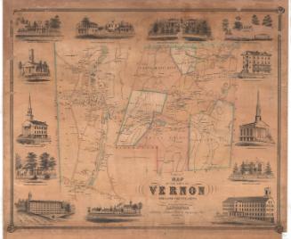
Map of Tolland County Connecticut
SurveyorSurveyed by
W. C. Eaton
(American, active 1855 - 1857)
SurveyorSurveyed by
H. C. Osborn
(American, active 1856 - 1857)
PrintmakerLithographed by
William H. Rease
(American, 1818 - after 1860)
MakerMade by
Wagner & McGuigan
(American, 1845 - 1859)
PublisherPublished by
Woodford & Bartlett
(American, active 1857)
PublisherCopyrighted by
E. M. Woodford
(American, 1824 - 1862)
Date1857
MediumLithography; printer's ink and watercolor on wove paper mounted on fabric
DimensionsPrimary Dimensions (image height x width): 53 x 46 1/2in. (134.6 x 118.1cm)
Sheet (height x width): 54 1/4 x 48in. (137.8 x 121.9cm)
ClassificationsGraphics
Credit LineMuseum purchase
Object number1918.6.1
DescriptionMap of Tolland County, Connecticut, with Massachusetts to the north; Ashford, Chaplin, and Windham, Connecticut to the east; Lebanon and Colchester to the south; and Marlborough, Glastonbury, Manchester, South Windsor, East Windsor, and Enfield to the west. Inset maps around the large map show the communities of Mansfield Center, Hebron, Somerville, Furnace Hollow, Rockville, Somers Street, Stafford Springs, Staffordville, Columbia, Tolland, Foxville, Eagleville, South Coventry, and Ellington Center. Ponds, swamps, hills, streams, rivers, roads, businesses, and property owners are shown on the main map and inset maps, with more detail on the inset maps. Elevation is indicated with hachure marks. Vignettes, set in a decorative border of grapevines, include J. H. Bolton's residence in Stafford; J. R. Brockway's residence in Ellington; the village of Stafford Springs, including the Springs Hotel and Granite Mill; Ellington Mills; Alanson Washburn's residence in Coventry; the monument to Nathan Hale in South Coventry; Hydeville Manufacturing Company in Stafford; N Kingsbury and Company's Mills in South Coventry; H. R. Fargo's Mills, South Coventry; a bank and courthouse, possibly in South Coventry; Hope Company's Satinet Mill in Staffordville; and E. Converse's residence in Stafford. A chart shows the population of each town in 1850, broken down into male and female, white and colored.
Label TextLarge town maps from the early 1850s vary remarkably in their style, layout, and even in the kinds of information that they include, but by the mid-1850s, when E. M. Woodford began publishing large county maps, he appears to have settled on a consistent formula, with the large county map itself surrounded by much smaller inset maps showing various communities, population tables, and a decorative border further embellished with vignettes of notable buildings. This 1857 map of Tolland County is the last map that Woodford is known to have produced. He published in partnership with someone named Bartlett. A native of Avon, Connecticut, Woodford was working in Philadelphia in the 1850s. Within a few years, he would be dead, one of the many Civil War soldiers to fall victim to disease rather than to combat injuries..
NotesCartographic Note: 1 1/2 inches equals one mileStatus
Not on view

Towne Crier Marketing, Inc..
1998