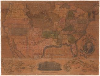
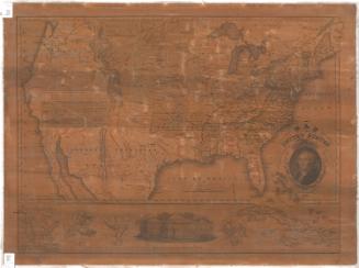
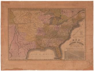
Map of the United States with its Territories.including also a part of Upper and Lower Canada and Mexico.
PublisherPublished by
Reed & Barber
(American, founded 1837)
Date1854
MediumEngraving; black printer's ink and watercolor on wove paper mounted on fabric
DimensionsPrimary Dimensions (image height x width): 28 1/4 x 42 1/4in. (71.8 x 107.3cm)
Sheet (height x width): 31 x 45 1/2in. (78.7 x 115.6cm)
Sheet (height x width): 31 x 45 1/2in. (78.7 x 115.6cm)
ClassificationsGraphics
Credit LineMuseum purchase
DescriptionMap of the United States with part of Canada to the north, the Atlantic Ocean to the east, the Gulf of Mexico and part of Mexico to the south, and the Pacific Ocean to the west. Territories include Nebraska Territory, Indian Territory, and Oregon Territory. Minnesota, Utah and Washington are not identified as territories, though they had not yet achieved statehood. The gold region of California is clearly indicated. Larger states are subdivided into counties. Names of major Indian tribes are shown. Rivers and mountains are shown; elevation is indicated by hachure marks. A vignette of the the United States Capitol appears beneath the title. A vignette showing the White House appears at lower center.
Object number2012.312.299
NotesCartographic Note:One and one half inches equals 100 milesOn View
Not on view

Samuel Augustus Mitchell
1835
Samuel Augustus Mitchell
1834