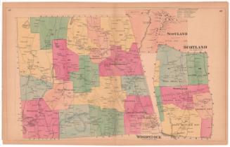
Map of Windham County Connecticut
SurveyorSurveyed by
W. C. Eaton
(American, active 1855 - 1857)
SurveyorSurveyed by
E. P. Gerrish
(American, active 1855 - 1856)
SurveyorSurveyed by
D. S. Osborn
(American, active 1855 - 1856)
SurveyorSurveyed by
H. C. Osborn
(American, active 1856 - 1857)
PrinterPrinted by
Wagner & McGuigan
(American, 1845 - 1859)
MakerMade by
William H. Rease
(American, 1818 - after 1860)
PublisherPublished by
E. M. Woodford
(American, 1824 - 1862)
Date1856
MediumLithography; black printer's ink and watercolor on wove paper mounted on fabric
DimensionsPrimary Dimensions (image height x width): 58 x 45 1/4in. (147.3 x 114.9cm)
Sheet (height x width): 60 x 47 1/4in. (152.4 x 120cm)
ClassificationsGraphics
Credit LineConnecticut Museum of Culture and History collection
Object number2012.312.297
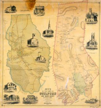
DescriptionMap of Windham County, Connecticut, with the town of Union, Connecticut and the state of Massachusetts to the north; Rhode Island to the east; North Stonington, Griswold, Lisbon, Franklin, and Lebanon to the south; and Mansfield and Willington to the west. Inset maps of Chaplin, Hampton, Windham, North Windham, South Windham, Willimantic, Woodstock, Thompson, Eastford, Brooklyn, Putnam, East Killingly, Daysville, Danielsonville, Central Village, and Almyville surround the main map. Ponds, swamps, hills, streams, rivers, roads, businesses, and property owners are shown on the main map and inset maps, with more detail on the inset maps. Elevation is indicated with hachure marks. Vignettes set in the decorative border at left and right depict the Z.N. Allen residence in North Ashford; Colonel William Alexander's house in Daysville; O. J. Lewis's house in Daysville; Putnam's wolf den; Wilkinson's Falls in Putnam; the court house in Brooklyn; Ballous Cotton Mill in Putnam; the mills of M.S. Morse and Company and C. Allen and G. C. Nightingale in Putnam Village; the Quinebaug House, an inn located at Putnam Station; the Hiram N. Brown house in Putnam; the William N. Chandler house in Thompson; and the W. H. Mason house in Thompson. A chart shows the population of each town in 1850, broken down into male and female, white and colored.
Label TextEdgar M. Woodford, who published this map, was a native of Avon, Connecticut. During the early 1850s, this self-taught surveyor was responsible for a number of large maps of New England towns, all published in Philadelphia by Richard Clark. In the mid-1850s, Woodford apparently moved to Philadelphia and began publishing maps on his own, employing the same lithographer and printer who had produced the later Clark maps. Huge county maps such as this one were a fad of the mid-1850s. Enormously detailed, they must have been expensive to produce, and it is hard to imagine that they appealed to a very broad audience. Ideal for hanging on the wall of a county courthouse, they were much too large for display in most ordinary homes or businesses, despite their considerable decorative appeal. The next decade would see the rise of county atlases, which incorporated individual town maps, and were much easier to store and use.
NotesCartographic Note: 1 1/2 inches equals one mileStatus
Not on view