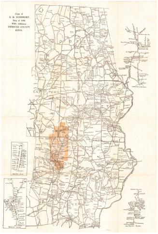
Map of Windham County Connecticut
SurveyorSurveyed by
W. C. Eaton
(American, active 1855 - 1857)
SurveyorSurveyed by
E. P. Gerrish
(American, active 1855 - 1856)
SurveyorSurveyed by
D. S. Osborn
(American, active 1855 - 1856)
SurveyorSurveyed by
H. C. Osborn
(American, active 1856 - 1857)
PrinterPrinted by
Wagner & McGuigan
(American, 1845 - 1859)
MakerMade by
William H. Rease
(American, 1818 - after 1860)
PublisherPublished by
E. M. Woodford
(American, 1824 - 1862)
Date1856
MediumLithography; black printer's ink and watercolor on wove paper mounted on fabric
DimensionsPrimary Dimensions (image height x width): 58 x 45 1/4in. (147.3 x 114.9cm)
Sheet (height x width): 60 x 47 1/4in. (152.4 x 120cm)
Sheet (height x width): 60 x 47 1/4in. (152.4 x 120cm)
ClassificationsGraphics
Credit LineConnecticut Museum of Culture and History collection
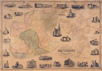
DescriptionMap of Windham County, Connecticut, with the town of Union, Connecticut and the state of Massachusetts to the north; Rhode Island to the east; North Stonington, Griswold, Lisbon, Franklin, and Lebanon to the south; and Mansfield and Willington to the west. Inset maps of Chaplin, Hampton, Windham, North Windham, South Windham, Willimantic, Woodstock, Thompson, Eastford, Brooklyn, Putnam, East Killingly, Daysville, Danielsonville, Central Village, and Almyville surround the main map. Ponds, swamps, hills, streams, rivers, roads, businesses, and property owners are shown on the main map and inset maps, with more detail on the inset maps. Elevation is indicated with hachure marks. Vignettes set in the decorative border at left and right depict the Z.N. Allen residence in North Ashford; Colonel William Alexander's house in Daysville; O. J. Lewis's house in Daysville; Putnam's wolf den; Wilkinson's Falls in Putnam; the court house in Brooklyn; Ballous Cotton Mill in Putnam; the mills of M.S. Morse and Company and C. Allen and G. C. Nightingale in Putnam Village; the Quinebaug House, an inn located at Putnam Station; the Hiram N. Brown house in Putnam; the William N. Chandler house in Thompson; and the W. H. Mason house in Thompson. A chart shows the population of each town in 1850, broken down into male and female, white and colored.
Object number2012.312.297
NotesCartographic Note: 1 1/2 inches equals one mileOn View
Not on view