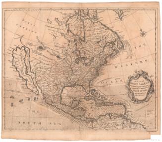
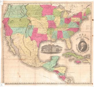
Map of the United States of America, the British Provinces, Mexico, the West Indies and Central America with part of New Grenada and Venezuela
DraftsmanDrawn by
George W. Colton
(American, 1827 - 1901)
PrintmakerEngraved by
J. M. Atwood
(American, active about 1840 - 1875)
PrintmakerBorder designed and engraved by
William S. Barnard
(American, born 1809)
PublisherPublished by
Joseph Hutchins Colton
(American, 1800 - 1893)
PublisherPublished by
John Ball
(American, active 1852)
PublisherPublished by
W. B. Babcock
(American, active 1852)
Date1852
MediumEngraving; printer's ink and watercolor on wove paper mounted on fabric
DimensionsPrimary Dimensions (image height x width): 33 1/2 x 42in. (85.1 x 106.7cm)
Sheet (height x width): 35 3/4 x 45in. (90.8 x 114.3cm)
ClassificationsGraphics
Credit LineConnecticut Museum of Culture and History collection
Object number2012.312.296
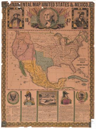
DescriptionMap of the United States, Mexico, Central America, and the Caribbean islands, with part of Canada to the north, part of South America to the south, the Atlantic Ocean to the east and the Pacific Ocean to the west. Smaller inset maps show the Isthmus of Panama with the route of the proposed railroad and the Atlantic Ocean with major American and European ports and the routes of the ocean steamers. Small steamships are shown on both this inset map and on the main map. The main map includes considerable detail for both political boundaries and geographical features within the area depicted. The map is surrounded by a decorative border of grapevines incorporating vignettes depicting the Willimmette Falls in Oregon; the Battle Monument in Baltimore, Maryland; the Pulaski Monument in Savannah, Georgia; the Cathedral in Mexico City; Mexicans capturing wild cattle; the entrance to a port; the United States Capitol in Washington, D.C.; the Valley of the Connecticut River; Saratoga Lake in New York State; and Astoria, Oregon.
Label TextColton's Map of the United States places the expanding nation in the context of its neighbors in the western hemisphere, with a special focus on Mexico, Central America, and the West Indies. An inset map expands this focus to include transatlantic trade. Mexico was of special interest because the Mexican War was still a very recent memory. The border between the two countries would not be finally resolved until the Gadsden purchase in 1853-1854. Panama was of interest because it provided one of the primary routes to the California gold fields. J. H. Colton issued the first edition of this map in 1848 and continued to issue revised editions to reflect the rapid changes that were taking place, especially in the American west and midwest, during the middle years of the nineteenth century.
NotesCartographic Note: One inch equals approximately 100 statute milesStatus
Not on view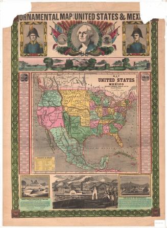

Ithamar P. Berthrong
1908