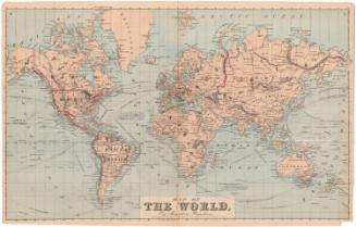
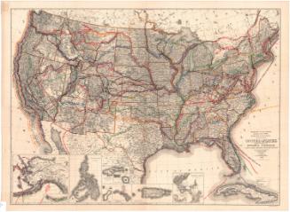
Map of the United States of America, the British Provinces, Mexico, the West Indies and Central America with part of New Grenada and Venezuela
DraftsmanDrawn by
George W. Colton
(American, 1827 - 1901)
PrintmakerEngraved by
J. M. Atwood
(American, active about 1840 - 1875)
PrintmakerBorder designed and engraved by
William S. Barnard
(American, born 1809)
PublisherPublished by
Joseph Hutchins Colton
(American, 1800 - 1893)
PublisherPublished by
John Ball
(American, active 1852)
PublisherPublished by
W. B. Babcock
(American, active 1852)
Date1852
MediumEngraving; printer's ink and watercolor on wove paper mounted on fabric
DimensionsPrimary Dimensions (image height x width): 33 1/2 x 42in. (85.1 x 106.7cm)
Sheet (height x width): 35 3/4 x 45in. (90.8 x 114.3cm)
Sheet (height x width): 35 3/4 x 45in. (90.8 x 114.3cm)
ClassificationsGraphics
Credit LineConnecticut Museum of Culture and History collection
DescriptionMap of the United States, Mexico, Central America, and the Caribbean islands, with part of Canada to the north, part of South America to the south, the Atlantic Ocean to the east and the Pacific Ocean to the west. Smaller inset maps show the Isthmus of Panama with the route of the proposed railroad and the Atlantic Ocean with major American and European ports and the routes of the ocean steamers. Small steamships are shown on both this inset map and on the main map. The main map includes considerable detail for both political boundaries and geographical features within the area depicted. The map is surrounded by a decorative border of grapevines incorporating vignettes depicting the Willimmette Falls in Oregon; the Battle Monument in Baltimore, Maryland; the Pulaski Monument in Savannah, Georgia; the Cathedral in Mexico City; Mexicans capturing wild cattle; the entrance to a port; the United States Capitol in Washington, D.C.; the Valley of the Connecticut River; Saratoga Lake in New York State; and Astoria, Oregon.
Object number2012.312.296
NotesCartographic Note: One inch equals approximately 100 statute milesOn View
Not on view

Ithamar P. Berthrong
1908