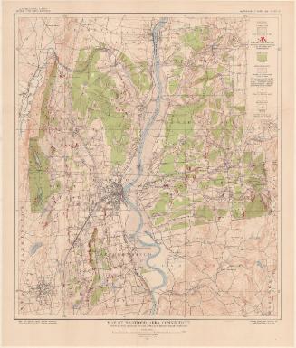
North half, Fairfield County, Connecticut
SurveyorSurveyed by
United States Geological Survey
(American, founded 1879)
MakerEdited by
United States Geological Survey
(American, founded 1879)
PublisherPublished by
United States Geological Survey
(American, founded 1879)
MakerMade by
Connecticut State Highway Department
(American, 1895 - 1969)
Date1979
MediumLithography; black and colored printer's inks on wove paper
DimensionsPrimary Dimensions (image height x width): 29 7/8 x 44 1/2in. (75.9 x 113cm)
Sheet (height x width): 35 3/4 x 47 5/8in. (90.8 x 121cm)
Sheet (height x width): 35 3/4 x 47 5/8in. (90.8 x 121cm)
ClassificationsGraphics
Credit LineMuseum purchase
DescriptionTopographical map of the north part of Fairfield County, Connecticut, showing elevation, wooded and urban areas, highways, local roads, swamps, parks, and water. The Housatonic River, ponds and lakes are colored blue. Shaded and open black squares are presumably used to denote buildings.
Object number1994.251.6
NotesCartographic Note: Scale: 1:50,000On View
Not on view