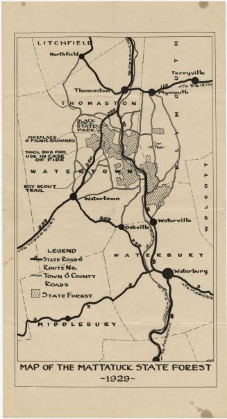
Talcott Mountain Forest Protective Association
PublisherPublished by
Talcott Mountain Forest Protective Association
(American)
Date1933
MediumLithography; balck and colored printer's inks on wove paper, lined in linen, bound in cardboard covers
DimensionsPrimary Dimensions (image height x width): 27 1/2 x 21 3/4in. (69.9 x 55.2cm)
Sheet (height x width): 29 1/4 x 23 1/4in. (74.3 x 59.1cm)
Mount (height x width): 29 1/4 x 23 1/4in. (74.3 x 59.1cm)
ClassificationsGraphics
Credit LineGift of Peter Brainard
Object number1979.103.1
DescriptionMap of parts of Litchfield and Hartford Counties, Connecticut, in the Talcott Mountain area, including Tunxis State Forest, Peoples and American Legion State Forest, and Nepaug State Forest, colored green. Blue denotes the Farmington River, reservoirs, lakes, and ponds. Orange is used to denote Talcott Mountain Forest Protective Association members' properties, which are numbered and correspond with a list bound into the covers with the map. The location of the Travelers Insurance Company tower in downtown Hartford is shown at the right.
Label TextWe think of fire towers as metal structures located on hills in the middle of forests, but beginning in 1929, a fire lookout was located in the tower of Travelers Insurance Company,then the tallest building in downtown Hartford. Equipment consisted of a map, a table, an alidade, and a telephone. A watcher was on duty from 9:00a.m. to 6:00 p.m. from April to mid-June and again from September to Thanksgiving. If a fire was sighted, its position was plotted on the map using the alidade, and the watcher telephoned the fire warden in the appropriate area. The watcher was paid by the Travelers Insurance Company; the telephone was paid for by the Talcott Mountain Forest Protective Association. Founded in the early twentieth century, the Talcott Mountain Forest Protective Association sought to preserve woodlands in central Connecticut at a time when Connecticut's forests were fast disappearing.
NotesCartographic Note: Scale: 1 inch equals 1 mileStatus
Not on view