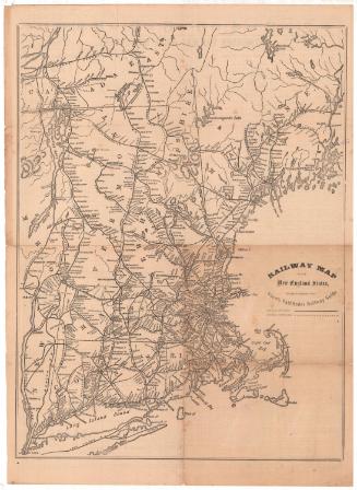
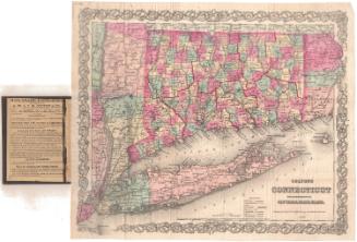
Railroad map of Massachusetts, Connecticut and Rhode Island
PrinterPrinted by
J. T. Powers & Co.
(American, 1852 - 1860)
Date1852-1860
MediumLithography; black printer's ink and watercolor on wove paper
DimensionsPrimary Dimensions (image height x width): 6 7/8 x 9 7/8in. (17.5 x 25.1cm)
Sheet (height x width): 9 5/8 x 12 1/8in. (24.4 x 30.8cm)
Sheet (height x width): 9 5/8 x 12 1/8in. (24.4 x 30.8cm)
ClassificationsGraphics
Credit LineGift of Ada M. Stearns
DescriptionMap of part of Massachusetts, part of Connecticut and Rhode Island, depicting the railroads in the area. The New Haven and New London; Naugatuck; Canal; New Haven and Springfield (colored brown); Hartford, Providence and Fishkill; Norwich and Worcester; Western (colored brown); Boston and Worcester (colored brown); and Providence and Stonington Railroads. The New York and Boston Railroad (also known as the Air Line) is marked with a crosshatched line (and colored red), while the other railroads are marked with solid lines for completed railroads or dotted lines for proposed railroads. Below the map is an explanation of the routes between New Haven and Boston.
Object number1928.11.1
NotesCartographic Note: No scale
Date Note: The map is dated on the basis of the dates of activity of the lithographer who printed it. The airline route was proposed as early as the 1840s and construction had not yet begun in 1860.On View
Not on view