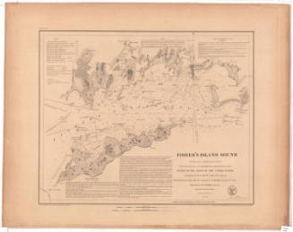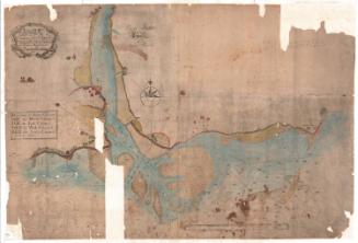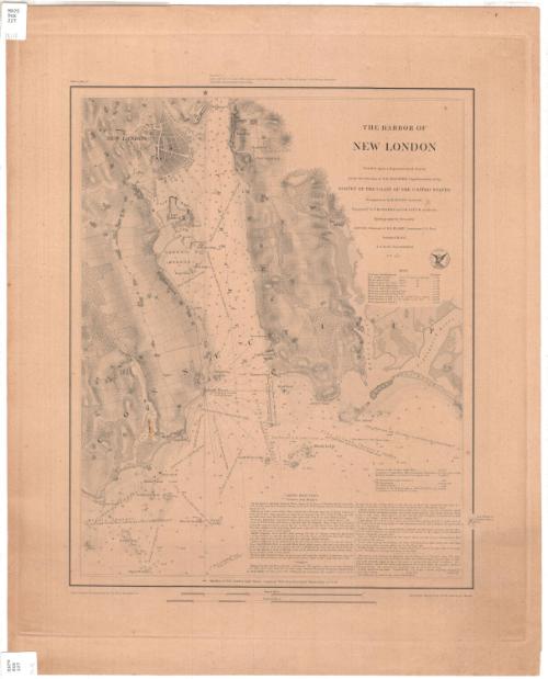
The Harbor of New London
PublisherPublished by
United States Coast Survey
(American, founded 1807)
SurveyorUnder the direction of
Ferdinand Rudolph Hassler
(American, 1770 - 1843)
SurveyorUnder the direction of
Alexander Dallas Bache
(American, 1806 - 1867)
SurveyorTriangulation by
Edmund Blunt
(American, 1799 - 1866)
SurveyorTopography by
Ferdinand H. Gerdes
(German-American, 1809 - 1884)
SurveyorTopography by
John B. Gluck
(American, died 1852)
SurveyorHydrography by
George S. Blake
(American, 1802 - 1871)
PrintmakerEngraved by
Albert Rolle
(German-American)
Date1848
MediumEngraving; printer's ink on wove paper
DimensionsPrimary Dimensions (image height x width): 17 1/4 x 14in. (43.8 x 35.6cm)
Platemark (height x width): 21 x 17 3/4in. (53.3 x 45.1cm)
Sheet (height x width): 23 x 18 1/2in. (58.4 x 47cm)
Platemark (height x width): 21 x 17 3/4in. (53.3 x 45.1cm)
Sheet (height x width): 23 x 18 1/2in. (58.4 x 47cm)
ClassificationsGraphics
Credit LineGift of the Charleston Library Society
DescriptionChart of New London Harbor and its approaches. The towns of New London and Groton are to the north, with the Thames River as far as Winthrop's Point and Winthrop's Cove. The chart extends as far east as the Poquannock River and Bushy Point Beach, and as far west as Goshen Point. Rapid Rock and Seaflower of Potter's Reef are to the south. Other features include the lighthouse at the entrance to the river, Eastern Point, Avery's Point, South West Ledge, Black Ledge, and Pine Island. The nature of the terrain on shore is indicated and roads, fields, and some buildings are shown. Elevation is indicated by hachure marks. Soundings are expressed in feet up to eighteen feet. Detailed sailing directions are at lower right.
Object number1995.205.4
NotesCartographic Note: Scale 1/20,000On View
Not on view