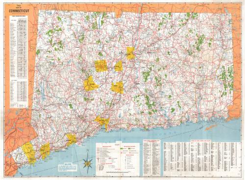
Map of Connecticut
PublisherPublished by
Connecticut State Highway Department
(American, 1895 - 1969)
MakerMade by
Connecticut Development Commission
(American, founded 1939)
MakerMade by
State Park and Forest Commission
(American, 1921 - 1971)
MakerMade by
State Board of Fisheries and Game
(American, 1913 - 1971)
Date1966
MediumOffset lithography; black and colored printer's inks on wove paper
DimensionsPrimary Dimensions (image height x width): 22 7/8 x 30 1/2in. (58.1 x 77.5cm)
Sheet (height x width): 23 1/2 x 31 1/4in. (59.7 x 79.4cm)
Sheet (height x width): 23 1/2 x 31 1/4in. (59.7 x 79.4cm)
ClassificationsGraphics
Credit LineConnecticut Museum of Culture and History collection
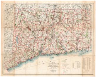
DescriptionMap of the state of Connecticut, with part of Massachusetts to the north, part of Rhode Island to the east, the Long Island Sound to the south, and part of New York to the west. The focus of the map is the system of highways and roads, showing interstates and state highways, including toll roads. Railroad lines and ferries are depicted as well. Cities are marked with circles varying in size according to population. The following towns are colored yellow: Hartford, New Britain, Bristol, Waterbury, Meriden, New Haven, Bridgeport/Stratford, Norwalk and Stamford. There is no explanation provided for this in the Legend. State parks and state forests are shown in green. Fish hatcheries, yacht clubs, airports, heliports, boat launching sites, rest areas, and forest fire lookout towers are also marked, with symbols. On the left side of the map is a table of the state parks, forests and monuments and their various features and activities. Below the map are a list of boat launching sites and an index to cities, towns and places.
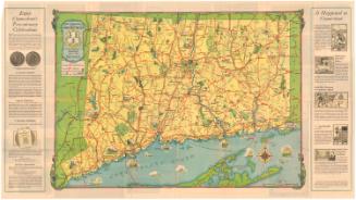
On the back are small maps of New Haven, Waterbury, Hartford, New London, Danbury, Bridgeport and Norwich, and a distance table for places in Connecticut, New York, Rhode Island, and Massachusetts. There are also color photographs of various natural and built features in the state. Highway regulations are also provided, as well as "offers to the general public," which include hunting and fishing fees and state park and forest information.
On the back are small maps of New Haven, Waterbury, Hartford, New London, Danbury, Bridgeport and Norwich, and a distance table for places in Connecticut, New York, Rhode Island, and Massachusetts. There are also color photographs of various natural and built features in the state. Highway regulations are also provided, as well as "offers to the general public," which include hunting and fishing fees and state park and forest information.
Object number2004.153.0
NotesCartographic Note: Scale: 1 inch equals 3 1/2 milesOn View
Not on view


Connecticut State Highway Department
1934