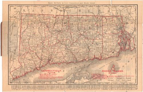
Rand, McNally & Co.'s Connecticut and Rhode Island
PublisherPublished by
Rand, McNally & Co.
(American, founded 1868)
Date1900
MediumLithography; black and red printer's ink on wove paper, in paper covers
DimensionsPrimary Dimensions (image height x width): 12 1/4 x 19 1/2in. (31.1 x 49.5cm)
Sheet (height x width): 14 x 21 1/8in. (35.6 x 53.7cm)
Sheet (height x width): 14 x 21 1/8in. (35.6 x 53.7cm)
ClassificationsGraphics
Credit LineConnecticut Museum of Culture and History collection
DescriptionMap of Connecticut and Rhode Island, with part of Massachusetts to the north and east, part of Long Island and the Long Island Sound to the south, and part of New York to the west. The states are divided into counties, outlined in red, and towns, outlined in broken solid lines. The railroad lines shown are marked with numbers, listed along with the express company that served the route at the bottom of the map by state. They are: in Connecticut, Central New England, Adams Express; Central Vermont, American Express; Hartford and West Hartford; Middletown, Meriden and Waterbury, Adams Express; New York, New Haven and Hartford, Adams Express; and South Manchester, Adams Express; and in Rhode Island, Moshassuck Valley; Narragansett Pier, Adams Express; New York, New Haven and Hartford, Adams Express, New York and Boston Express, Despatch Express and Earle & Prew Express; Newport and Wickford Railroad and steamboat line, Adams Express; Pawcatuck Valley, Adams Express; and Wood River Branch, Local Express. Physical features depicted include rivers and lakes. Below the map and on the back of the sheet are indexes to the counties, bays, islands, lakes, rivers, and towns for both states.
Object number2004.148.0
NotesCartographic Note: Scale: 1 inch equals 7 milesOn View
Not on view