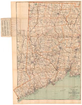
Trolley Pathfinder Birds Eye Map of Interurban Trolley Lines in New England
PrinterPrinted by
Geo. H. Walker & Co.
(American, founded 1880)
Date1905
MediumLithography; black and colored printer's inks on wove paper, in paper covers
DimensionsPrimary Dimensions (image height x width): 13 7/8 x 20 1/2in. (35.2 x 52.1cm)
Sheet (height x width): 14 x 20 7/8in. (35.6 x 53cm)
ClassificationsGraphics
Credit LineConnecticut Museum of Culture and History collection
Object number2004.147.0
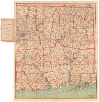
DescriptionBirds's eye view pocket map of the trolley system in southern New England, oriented on the sheet with Boston as the focal point at the bottom, and the Long Island Sound and Connecticut in the top left corner. The states shown are Connecticut, Rhode Island, Massachusetts, and southern New Hampshire. Cities are depicted as clusters of buildings and are colored orange, with orange trolley lines running between them. The spaces in between urban centers are portrayed as green, wooded areas. Railroad lines are shown in black and are not labeled, and parks are shown in orange. On the inside of the cover is information from the Street Railway Passenger Department in Boston, providing short descriptions of the scenery along the routes it services.
Label TextIt's easy to tell that the publisher of this 1905 birds-eye map of New England's interurban trolley system was based in Boston. Boston looms large in the foreground and the trolley connections between Boston and nearby towns are relatively easy to interpret. The farther one gets from Boston, however, the more difficult it is to tell precisely where the different lines interconnect. Virtually useless as a practical guide, this little map nevertheless provides an impressive overview of the extent of trolley service in the early twentieth century. The extensive areas of green also suggest that most most of southern New England was still open coutnryside. While this may or may not have been literally true in all of the areas depicted, it was true that trolley companies encouraged passengers to take the trolley not only to get from one town to the other, but also as a way to get out and explore the countryside.
NotesCartographic Note: No scaleStatus
Not on view

Rand Avery Supply Co.
about 1900
Unknown